You are here: Home > Network List > TA - USArray Transportable Network (new EarthScope stations) Stations List
> Station E21K Killik River, AK, USA > Earthquake Result Viewer
E21K Killik River, AK, USA - Earthquake Result Viewer
| Earthquake location: |
New Ireland Region, P.N.G. |
| Earthquake latitude/longitude: |
-3.4/152.1 |
| Earthquake time(UTC): |
2019/02/17 (048) 14:35:56 GMT |
| Earthquake Depth: |
368 km |
| Earthquake Magnitude: |
6.4 Mww |
| Earthquake Catalog/Contributor: |
NEIC PDE/us |
|
| Network: |
TA USArray Transportable Network (new EarthScope stations) |
| Station: |
E21K Killik River, AK, USA |
| Lat/Lon: |
68.44 N/153.97 W |
| Elevation: |
653 m |
|
| Distance: |
80.6 deg |
| Az: |
17.622 deg |
| Baz: |
234.855 deg |
| Ray Param: |
0.047137056 |
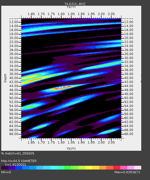
| Estimated Moho Depth: |
44.5 km |
| Estimated Crust Vp/Vs: |
1.81 |
| Assumed Crust Vp: |
6.221 km/s |
| Estimated Crust Vs: |
3.437 km/s |
| Estimated Crust Poisson's Ratio: |
0.28 |
|
| Radial Match: |
81.285805 % |
| Radial Bump: |
400 |
| Transverse Match: |
79.49659 % |
| Transverse Bump: |
400 |
| SOD ConfigId: |
13570011 |
| Insert Time: |
2019-05-02 13:22:01.047 +0000 |
| GWidth: |
2.5 |
| Max Bumps: |
400 |
| Tol: |
0.001 |
|

Signal To Noise
| Channel | StoN | STA | LTA |
| TA:E21K: :BHZ:20190217T14:46:57.150005Z | 18.82638 | 3.7651423E-6 | 1.999929E-7 |
| TA:E21K: :BHN:20190217T14:46:57.150005Z | 5.501576 | 1.0466271E-6 | 1.9024131E-7 |
| TA:E21K: :BHE:20190217T14:46:57.150005Z | 4.9292655 | 1.0239514E-6 | 2.0772899E-7 |
| Arrivals |
| Ps | 5.9 SECOND |
| PpPs | 20 SECOND |
| PsPs/PpSs | 26 SECOND |


