You are here: Home > Network List > TA - USArray Transportable Network (new EarthScope stations) Stations List
> Station F14K Arctic Creek, AK, USA > Earthquake Result Viewer
F14K Arctic Creek, AK, USA - Earthquake Result Viewer
| Earthquake location: |
New Ireland Region, P.N.G. |
| Earthquake latitude/longitude: |
-3.4/152.1 |
| Earthquake time(UTC): |
2019/02/17 (048) 14:35:56 GMT |
| Earthquake Depth: |
368 km |
| Earthquake Magnitude: |
6.4 Mww |
| Earthquake Catalog/Contributor: |
NEIC PDE/us |
|
| Network: |
TA USArray Transportable Network (new EarthScope stations) |
| Station: |
F14K Arctic Creek, AK, USA |
| Lat/Lon: |
65.47 N/166.33 W |
| Elevation: |
266 m |
|
| Distance: |
75.0 deg |
| Az: |
16.659 deg |
| Baz: |
223.282 deg |
| Ray Param: |
0.050880797 |
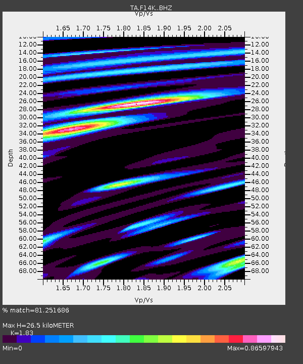
| Estimated Moho Depth: |
26.5 km |
| Estimated Crust Vp/Vs: |
1.83 |
| Assumed Crust Vp: |
6.307 km/s |
| Estimated Crust Vs: |
3.446 km/s |
| Estimated Crust Poisson's Ratio: |
0.29 |
|
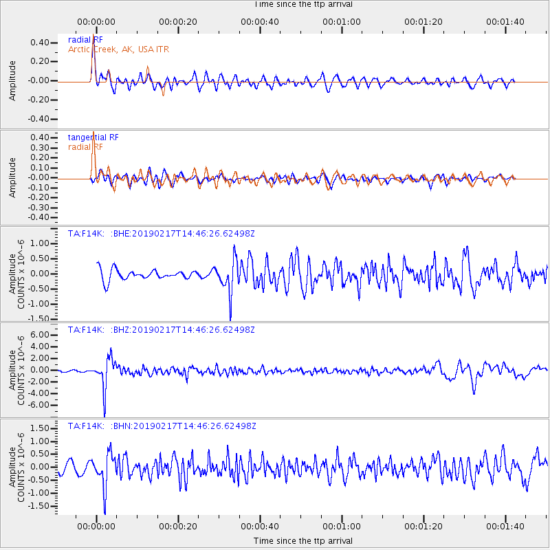
| Radial Match: |
81.251686 % |
| Radial Bump: |
400 |
| Transverse Match: |
62.69067 % |
| Transverse Bump: |
400 |
| SOD ConfigId: |
13570011 |
| Insert Time: |
2019-05-02 13:22:05.610 +0000 |
| GWidth: |
2.5 |
| Max Bumps: |
400 |
| Tol: |
0.001 |
|
Signal To Noise
| Channel | StoN | STA | LTA |
| TA:F14K: :BHZ:20190217T14:46:26.62498Z | 9.879926 | 2.5183544E-6 | 2.548961E-7 |
| TA:F14K: :BHN:20190217T14:46:26.62498Z | 3.1736937 | 6.3937506E-7 | 2.0146086E-7 |
| TA:F14K: :BHE:20190217T14:46:26.62498Z | 3.5063803 | 5.484456E-7 | 1.5641362E-7 |
| Arrivals |
| Ps | 3.6 SECOND |
| PpPs | 12 SECOND |
| PsPs/PpSs | 15 SECOND |


