You are here: Home > Network List > TA - USArray Transportable Network (new EarthScope stations) Stations List
> Station I23K Minto, Yukon-Koyukuk, AK, USA > Earthquake Result Viewer
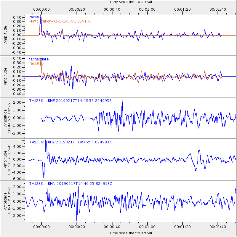
I23K Minto, Yukon-Koyukuk, AK, USA - Earthquake Result Viewer
*The percent match for this event was below the threshold and hence no stack was calculated.
| Earthquake location: |
New Ireland Region, P.N.G. |
| Earthquake latitude/longitude: |
-3.4/152.1 |
| Earthquake time(UTC): |
2019/02/17 (048) 14:35:56 GMT |
| Earthquake Depth: |
368 km |
| Earthquake Magnitude: |
6.4 Mww |
| Earthquake Catalog/Contributor: |
NEIC PDE/us |
|
| Network: |
TA USArray Transportable Network (new EarthScope stations) |
| Station: |
I23K Minto, Yukon-Koyukuk, AK, USA |
| Lat/Lon: |
65.15 N/149.36 W |
| Elevation: |
149 m |
|
| Distance: |
80.4 deg |
| Az: |
21.444 deg |
| Baz: |
239.722 deg |
| Ray Param: |
$rayparam |
*The percent match for this event was below the threshold and hence was not used in the summary stack. |
|
| Radial Match: |
73.32821 % |
| Radial Bump: |
400 |
| Transverse Match: |
64.074585 % |
| Transverse Bump: |
400 |
| SOD ConfigId: |
13570011 |
| Insert Time: |
2019-05-02 13:22:38.561 +0000 |
| GWidth: |
2.5 |
| Max Bumps: |
400 |
| Tol: |
0.001 |
|
Signal To Noise
| Channel | StoN | STA | LTA |
| TA:I23K: :BHZ:20190217T14:46:55.824993Z | 15.714929 | 2.8499833E-6 | 1.8135515E-7 |
| TA:I23K: :BHN:20190217T14:46:55.824993Z | 2.2129724 | 8.0672334E-7 | 3.645429E-7 |
| TA:I23K: :BHE:20190217T14:46:55.824993Z | 2.685911 | 6.36698E-7 | 2.3705107E-7 |
| Arrivals |
| Ps | |
| PpPs | |
| PsPs/PpSs | |


