You are here: Home > Network List > TA - USArray Transportable Network (new EarthScope stations) Stations List
> Station J30M Hart River, Yukon, CAN > Earthquake Result Viewer
J30M Hart River, Yukon, CAN - Earthquake Result Viewer
| Earthquake location: |
New Ireland Region, P.N.G. |
| Earthquake latitude/longitude: |
-3.4/152.1 |
| Earthquake time(UTC): |
2019/02/17 (048) 14:35:56 GMT |
| Earthquake Depth: |
368 km |
| Earthquake Magnitude: |
6.4 Mww |
| Earthquake Catalog/Contributor: |
NEIC PDE/us |
|
| Network: |
TA USArray Transportable Network (new EarthScope stations) |
| Station: |
J30M Hart River, Yukon, CAN |
| Lat/Lon: |
64.58 N/136.33 W |
| Elevation: |
1419 m |
|
| Distance: |
85.2 deg |
| Az: |
24.264 deg |
| Baz: |
251.867 deg |
| Ray Param: |
0.04397208 |
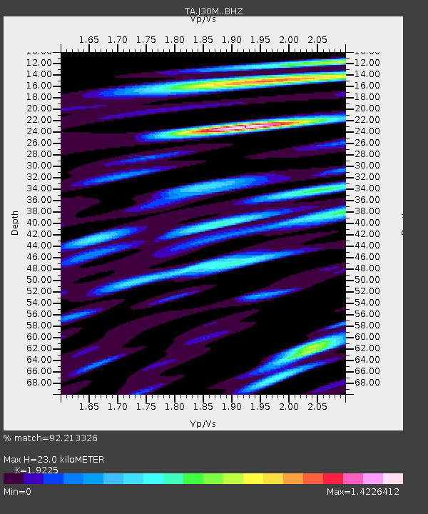
| Estimated Moho Depth: |
23.0 km |
| Estimated Crust Vp/Vs: |
1.92 |
| Assumed Crust Vp: |
6.566 km/s |
| Estimated Crust Vs: |
3.415 km/s |
| Estimated Crust Poisson's Ratio: |
0.31 |
|
| Radial Match: |
92.213326 % |
| Radial Bump: |
400 |
| Transverse Match: |
86.038864 % |
| Transverse Bump: |
400 |
| SOD ConfigId: |
13570011 |
| Insert Time: |
2019-05-02 13:22:52.523 +0000 |
| GWidth: |
2.5 |
| Max Bumps: |
400 |
| Tol: |
0.001 |
|

Signal To Noise
| Channel | StoN | STA | LTA |
| TA:J30M: :BHZ:20190217T14:47:20.324993Z | 33.943146 | 5.0596655E-6 | 1.4906296E-7 |
| TA:J30M: :BHN:20190217T14:47:20.324993Z | 10.196534 | 1.5654263E-6 | 1.5352532E-7 |
| TA:J30M: :BHE:20190217T14:47:20.324993Z | 18.71086 | 2.3635412E-6 | 1.2631922E-7 |
| Arrivals |
| Ps | 3.3 SECOND |
| PpPs | 10 SECOND |
| PsPs/PpSs | 13 SECOND |


