You are here: Home > Network List > TA - USArray Transportable Network (new EarthScope stations) Stations List
> Station L21A Rawlins, WY, USA > Earthquake Result Viewer
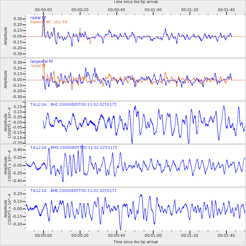
L21A Rawlins, WY, USA - Earthquake Result Viewer
*The percent match for this event was below the threshold and hence no stack was calculated.
| Earthquake location: |
Southwestern Ryukyu Isl., Japan |
| Earthquake latitude/longitude: |
24.2/125.1 |
| Earthquake time(UTC): |
2009/08/05 (217) 00:17:58 GMT |
| Earthquake Depth: |
25 km |
| Earthquake Magnitude: |
5.9 MB, 5.9 MS, 6.2 MW, 6.1 MW |
| Earthquake Catalog/Contributor: |
WHDF/NEIC |
|
| Network: |
TA USArray Transportable Network (new EarthScope stations) |
| Station: |
L21A Rawlins, WY, USA |
| Lat/Lon: |
41.96 N/107.37 W |
| Elevation: |
2065 m |
|
| Distance: |
98.2 deg |
| Az: |
36.693 deg |
| Baz: |
312.994 deg |
| Ray Param: |
$rayparam |
*The percent match for this event was below the threshold and hence was not used in the summary stack. |
|
| Radial Match: |
71.7152 % |
| Radial Bump: |
400 |
| Transverse Match: |
66.51835 % |
| Transverse Bump: |
390 |
| SOD ConfigId: |
2622 |
| Insert Time: |
2010-03-06 20:11:05.572 +0000 |
| GWidth: |
2.5 |
| Max Bumps: |
400 |
| Tol: |
0.001 |
|
Signal To Noise
| Channel | StoN | STA | LTA |
| TA:L21A: :BHN:20090805T00:31:02.025017Z | 4.098666 | 1.7728995E-7 | 4.3255525E-8 |
| TA:L21A: :BHE:20090805T00:31:02.025017Z | 1.4233477 | 7.276376E-8 | 5.1121567E-8 |
| TA:L21A: :BHZ:20090805T00:31:02.025017Z | 1.2464954 | 4.8465825E-8 | 3.8881673E-8 |
| Arrivals |
| Ps | |
| PpPs | |
| PsPs/PpSs | |


