You are here: Home > Network List > TA - USArray Transportable Network (new EarthScope stations) Stations List
> Station L21A Rawlins, WY, USA > Earthquake Result Viewer
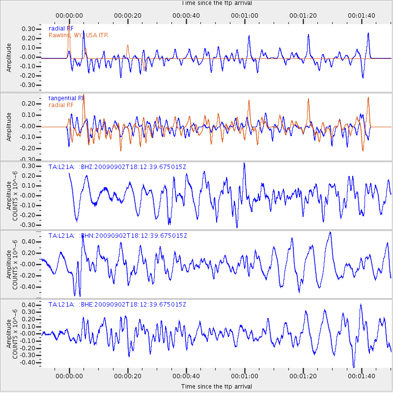
L21A Rawlins, WY, USA - Earthquake Result Viewer
*The percent match for this event was below the threshold and hence no stack was calculated.
| Earthquake location: |
Kermadec Islands, New Zealand |
| Earthquake latitude/longitude: |
-29.4/-179.0 |
| Earthquake time(UTC): |
2009/09/02 (245) 18:00:11 GMT |
| Earthquake Depth: |
275 km |
| Earthquake Magnitude: |
5.8 MB, 6.2 MW, 6.1 MW |
| Earthquake Catalog/Contributor: |
WHDF/NEIC |
|
| Network: |
TA USArray Transportable Network (new EarthScope stations) |
| Station: |
L21A Rawlins, WY, USA |
| Lat/Lon: |
41.96 N/107.37 W |
| Elevation: |
2065 m |
|
| Distance: |
96.8 deg |
| Az: |
45.455 deg |
| Baz: |
236.539 deg |
| Ray Param: |
$rayparam |
*The percent match for this event was below the threshold and hence was not used in the summary stack. |
|
| Radial Match: |
56.018864 % |
| Radial Bump: |
400 |
| Transverse Match: |
56.990604 % |
| Transverse Bump: |
400 |
| SOD ConfigId: |
2622 |
| Insert Time: |
2010-03-06 20:11:13.737 +0000 |
| GWidth: |
2.5 |
| Max Bumps: |
400 |
| Tol: |
0.001 |
|
Signal To Noise
| Channel | StoN | STA | LTA |
| TA:L21A: :BHN:20090902T18:12:39.675015Z | 3.957223 | 3.0249424E-7 | 7.644105E-8 |
| TA:L21A: :BHE:20090902T18:12:39.675015Z | 1.1707585 | 8.8378506E-8 | 7.5488245E-8 |
| TA:L21A: :BHZ:20090902T18:12:39.675015Z | 1.5935338 | 1.6421536E-7 | 1.0305108E-7 |
| Arrivals |
| Ps | |
| PpPs | |
| PsPs/PpSs | |


