You are here: Home > Network List > TA - USArray Transportable Network (new EarthScope stations) Stations List
> Station L21A Rawlins, WY, USA > Earthquake Result Viewer
L21A Rawlins, WY, USA - Earthquake Result Viewer
*The percent match for this event was below the threshold and hence no stack was calculated.
| Earthquake location: |
San Juan Province, Argentina |
| Earthquake latitude/longitude: |
-31.9/-69.2 |
| Earthquake time(UTC): |
2009/03/11 (070) 13:06:53 GMT |
| Earthquake Depth: |
28 km |
| Earthquake Magnitude: |
5.5 MB, 4.8 MS, 5.3 MW, 5.5 ML |
| Earthquake Catalog/Contributor: |
WHDF/NEIC |
|
| Network: |
TA USArray Transportable Network (new EarthScope stations) |
| Station: |
L21A Rawlins, WY, USA |
| Lat/Lon: |
41.96 N/107.37 W |
| Elevation: |
2065 m |
|
| Distance: |
81.5 deg |
| Az: |
332.214 deg |
| Baz: |
147.876 deg |
| Ray Param: |
$rayparam |
*The percent match for this event was below the threshold and hence was not used in the summary stack. |
|
| Radial Match: |
45.9441 % |
| Radial Bump: |
400 |
| Transverse Match: |
39.61025 % |
| Transverse Bump: |
354 |
| SOD ConfigId: |
2658 |
| Insert Time: |
2010-03-06 20:11:33.531 +0000 |
| GWidth: |
2.5 |
| Max Bumps: |
400 |
| Tol: |
0.001 |
|
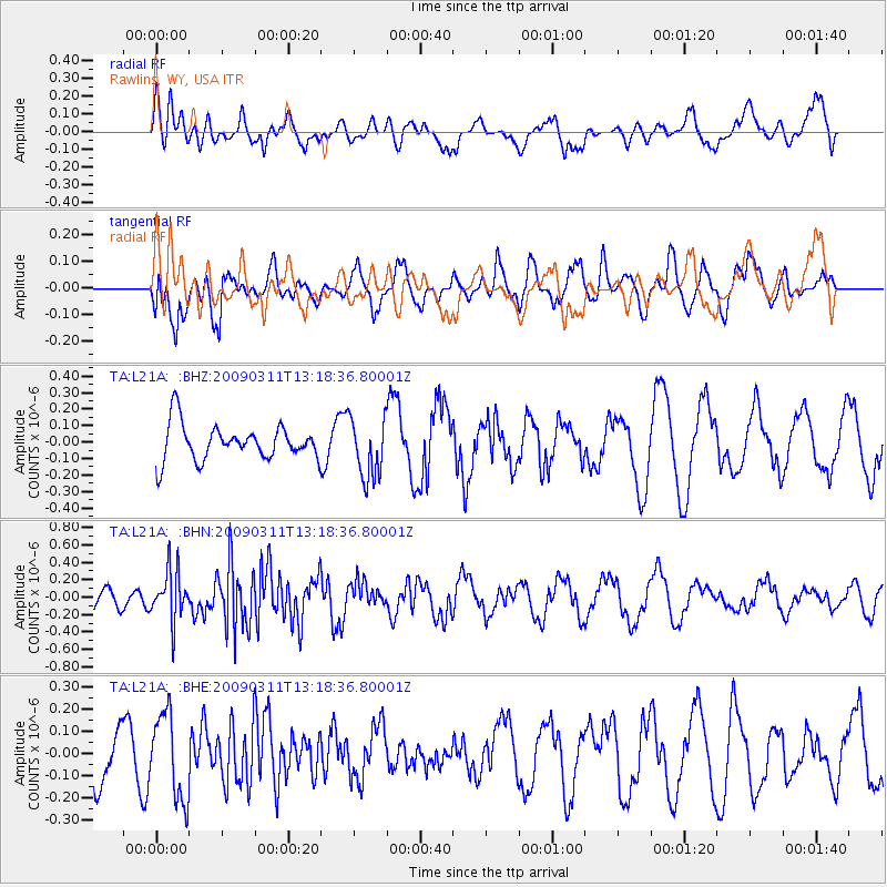
Signal To Noise
| Channel | StoN | STA | LTA |
| TA:L21A: :BHN:20090311T13:18:36.80001Z | 3.1604052 | 2.8579387E-7 | 9.042951E-8 |
| TA:L21A: :BHE:20090311T13:18:36.80001Z | 1.3073872 | 1.9086723E-7 | 1.4599135E-7 |
| TA:L21A: :BHZ:20090311T13:18:36.80001Z | 1.6807301 | 1.8141809E-7 | 1.0794005E-7 |
| Arrivals |
| Ps | |
| PpPs | |
| PsPs/PpSs | |


