You are here: Home > Network List > TA - USArray Transportable Network (new EarthScope stations) Stations List
> Station L21A Rawlins, WY, USA > Earthquake Result Viewer
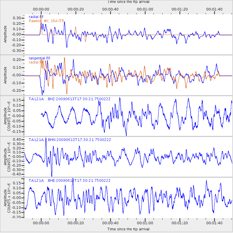
L21A Rawlins, WY, USA - Earthquake Result Viewer
*The percent match for this event was below the threshold and hence no stack was calculated.
| Earthquake location: |
Eastern Kazakhstan |
| Earthquake latitude/longitude: |
44.7/78.9 |
| Earthquake time(UTC): |
2009/06/13 (164) 17:17:38 GMT |
| Earthquake Depth: |
14 km |
| Earthquake Magnitude: |
5.8 MB, 5.1 MS, 5.4 MW, 5.4 MW |
| Earthquake Catalog/Contributor: |
WHDF/NEIC |
|
| Network: |
TA USArray Transportable Network (new EarthScope stations) |
| Station: |
L21A Rawlins, WY, USA |
| Lat/Lon: |
41.96 N/107.37 W |
| Elevation: |
2065 m |
|
| Distance: |
93.5 deg |
| Az: |
4.654 deg |
| Baz: |
355.552 deg |
| Ray Param: |
$rayparam |
*The percent match for this event was below the threshold and hence was not used in the summary stack. |
|
| Radial Match: |
68.95342 % |
| Radial Bump: |
400 |
| Transverse Match: |
65.8942 % |
| Transverse Bump: |
400 |
| SOD ConfigId: |
2648 |
| Insert Time: |
2010-03-06 20:11:39.578 +0000 |
| GWidth: |
2.5 |
| Max Bumps: |
400 |
| Tol: |
0.001 |
|
Signal To Noise
| Channel | StoN | STA | LTA |
| TA:L21A: :BHN:20090613T17:30:21.750022Z | 1.7366333 | 1.4626978E-7 | 8.4226066E-8 |
| TA:L21A: :BHE:20090613T17:30:21.750022Z | 0.6426156 | 5.5305627E-8 | 8.606332E-8 |
| TA:L21A: :BHZ:20090613T17:30:21.750022Z | 1.3815105 | 7.479048E-8 | 5.4136745E-8 |
| Arrivals |
| Ps | |
| PpPs | |
| PsPs/PpSs | |


