You are here: Home > Network List > G - GEOSCOPE Stations List
> Station NOUC Port Laguerre, New Caledonia > Earthquake Result Viewer
NOUC Port Laguerre, New Caledonia - Earthquake Result Viewer

| Earthquake location: |
Southeast Of Honshu, Japan |
| Earthquake latitude/longitude: |
30.5/142.1 |
| Earthquake time(UTC): |
2016/09/20 (264) 16:21:16 GMT |
| Earthquake Depth: |
10 km |
| Earthquake Magnitude: |
6.1 MWW, 6.0 MWB |
| Earthquake Catalog/Contributor: |
NEIC PDE/NEIC COMCAT |
|
| Network: |
G GEOSCOPE |
| Station: |
NOUC Port Laguerre, New Caledonia |
| Lat/Lon: |
22.10 S/166.30 E |
| Elevation: |
112 m |
|
| Distance: |
57.3 deg |
| Az: |
153.109 deg |
| Baz: |
335.116 deg |
| Ray Param: |
0.06359293 |
| Estimated Moho Depth: |
13.0 km |
| Estimated Crust Vp/Vs: |
1.91 |
| Assumed Crust Vp: |
5.14 km/s |
| Estimated Crust Vs: |
2.691 km/s |
| Estimated Crust Poisson's Ratio: |
0.31 |
|
| Radial Match: |
82.62547 % |
| Radial Bump: |
400 |
| Transverse Match: |
77.58012 % |
| Transverse Bump: |
400 |
| SOD ConfigId: |
1634031 |
| Insert Time: |
2016-10-04 16:22:38.586 +0000 |
| GWidth: |
2.5 |
| Max Bumps: |
400 |
| Tol: |
0.001 |
|
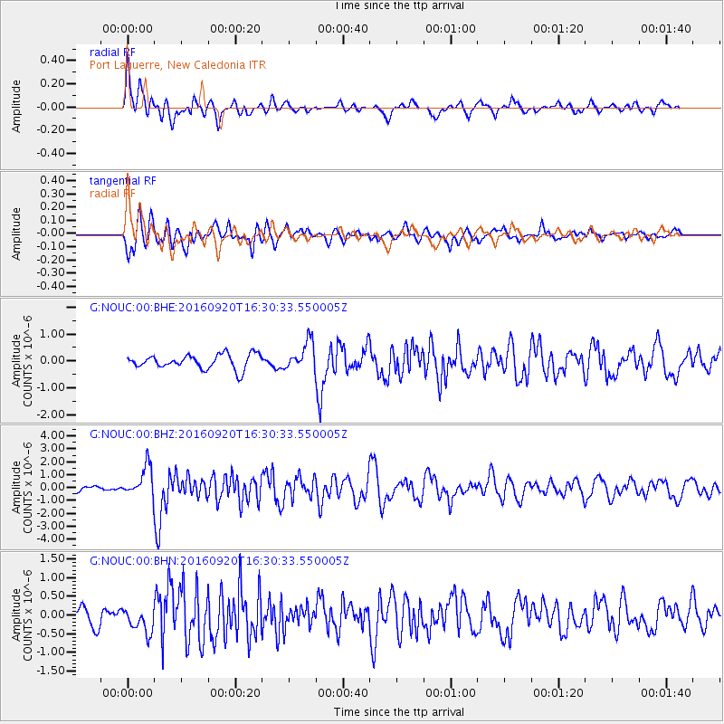
Signal To Noise
| Channel | StoN | STA | LTA |
| G:NOUC:00:BHZ:20160920T16:30:33.550005Z | 6.6932836 | 1.1857402E-6 | 1.7715374E-7 |
| G:NOUC:00:BHN:20160920T16:30:33.550005Z | 1.2866436 | 3.2499798E-7 | 2.5259362E-7 |
| G:NOUC:00:BHE:20160920T16:30:33.550005Z | 1.9968704 | 5.2818973E-7 | 2.6450877E-7 |
| Arrivals |
| Ps | 2.4 SECOND |
| PpPs | 7.1 SECOND |
| PsPs/PpSs | 9.5 SECOND |


