You are here: Home > Network List > TS - TERRAscope (Southern California Seismic Network) Stations List
> Station CWC Cottonwood Creek Canyon, California, USA > Earthquake Result Viewer
CWC Cottonwood Creek Canyon, California, USA - Earthquake Result Viewer
| Earthquake location: |
Santa Cruz Islands |
| Earthquake latitude/longitude: |
-12.9/166.5 |
| Earthquake time(UTC): |
1997/04/21 (111) 12:06:34 GMT |
| Earthquake Depth: |
33 km |
| Earthquake Magnitude: |
6.1 MB |
| Earthquake Catalog/Contributor: |
WHDF/NEIC |
|
| Network: |
TS TERRAscope (Southern California Seismic Network) |
| Station: |
CWC Cottonwood Creek Canyon, California, USA |
| Lat/Lon: |
36.44 N/118.08 W |
| Elevation: |
1553 m |
|
| Distance: |
86.2 deg |
| Az: |
51.469 deg |
| Baz: |
251.085 deg |
| Ray Param: |
0.044186942 |
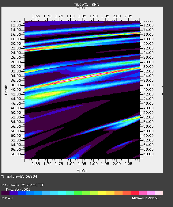
| Estimated Moho Depth: |
34.25 km |
| Estimated Crust Vp/Vs: |
1.86 |
| Assumed Crust Vp: |
6.291 km/s |
| Estimated Crust Vs: |
3.387 km/s |
| Estimated Crust Poisson's Ratio: |
0.30 |
|
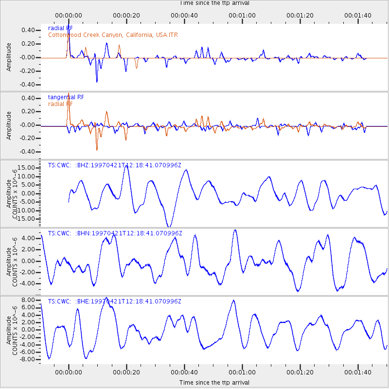
| Radial Match: |
85.06364 % |
| Radial Bump: |
331 |
| Transverse Match: |
62.048084 % |
| Transverse Bump: |
400 |
| SOD ConfigId: |
6273 |
| Insert Time: |
2010-02-26 14:05:51.527 +0000 |
| GWidth: |
2.5 |
| Max Bumps: |
400 |
| Tol: |
0.001 |
|
Signal To Noise
| Channel | StoN | STA | LTA |
| TS:CWC: :BHN:19970421T12:18:41.070996Z | 0.39470923 | 1.2461353E-6 | 3.157097E-6 |
| TS:CWC: :BHE:19970421T12:18:41.070996Z | 0.8802363 | 3.403165E-6 | 3.8661947E-6 |
| TS:CWC: :BHZ:19970421T12:18:41.070996Z | 1.5362273 | 1.0507038E-5 | 6.839507E-6 |
| Arrivals |
| Ps | 4.8 SECOND |
| PpPs | 15 SECOND |
| PsPs/PpSs | 20 SECOND |


