You are here: Home > Network List > TA - USArray Transportable Network (new EarthScope stations) Stations List
> Station L21A Rawlins, WY, USA > Earthquake Result Viewer
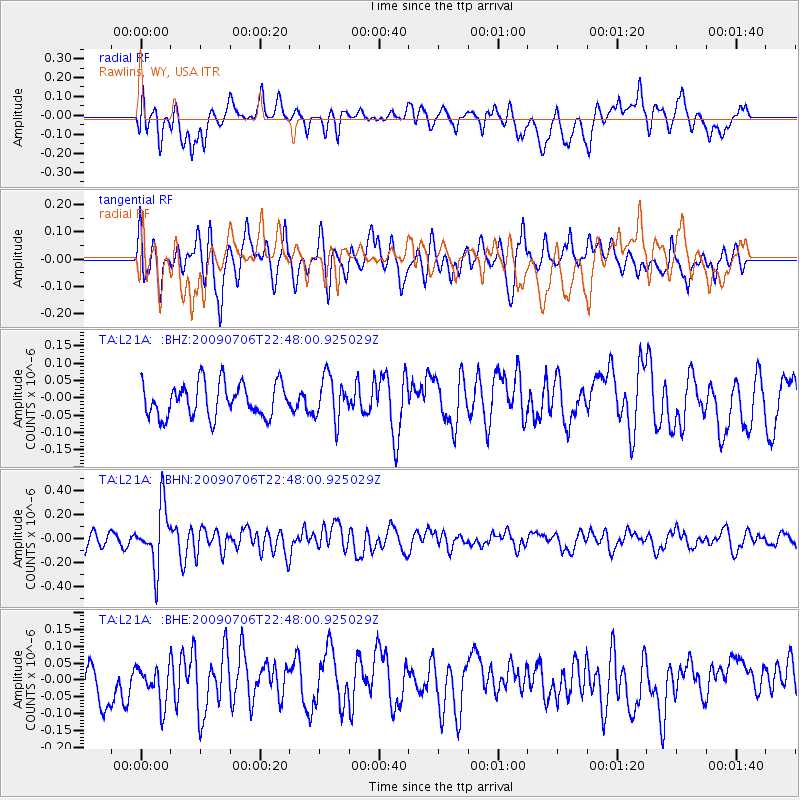
L21A Rawlins, WY, USA - Earthquake Result Viewer
*The percent match for this event was below the threshold and hence no stack was calculated.
| Earthquake location: |
Southeast Of Ryukyu Islands |
| Earthquake latitude/longitude: |
24.9/128.0 |
| Earthquake time(UTC): |
2009/07/06 (187) 22:35:05 GMT |
| Earthquake Depth: |
10 km |
| Earthquake Magnitude: |
6.1 MB, 5.3 MS, 5.7 MW, 5.7 MW |
| Earthquake Catalog/Contributor: |
WHDF/NEIC |
|
| Network: |
TA USArray Transportable Network (new EarthScope stations) |
| Station: |
L21A Rawlins, WY, USA |
| Lat/Lon: |
41.96 N/107.37 W |
| Elevation: |
2065 m |
|
| Distance: |
96.1 deg |
| Az: |
38.122 deg |
| Baz: |
311.248 deg |
| Ray Param: |
$rayparam |
*The percent match for this event was below the threshold and hence was not used in the summary stack. |
|
| Radial Match: |
54.4954 % |
| Radial Bump: |
400 |
| Transverse Match: |
55.381893 % |
| Transverse Bump: |
400 |
| SOD ConfigId: |
2648 |
| Insert Time: |
2010-03-06 20:11:51.318 +0000 |
| GWidth: |
2.5 |
| Max Bumps: |
400 |
| Tol: |
0.001 |
|
Signal To Noise
| Channel | StoN | STA | LTA |
| TA:L21A: :BHN:20090706T22:48:00.925029Z | 4.163151 | 2.4737315E-7 | 5.9419698E-8 |
| TA:L21A: :BHE:20090706T22:48:00.925029Z | 1.0796254 | 5.5436583E-8 | 5.1347982E-8 |
| TA:L21A: :BHZ:20090706T22:48:00.925029Z | 1.2821163 | 6.202572E-8 | 4.8377608E-8 |
| Arrivals |
| Ps | |
| PpPs | |
| PsPs/PpSs | |


