You are here: Home > Network List > TA - USArray Transportable Network (new EarthScope stations) Stations List
> Station L21A Rawlins, WY, USA > Earthquake Result Viewer
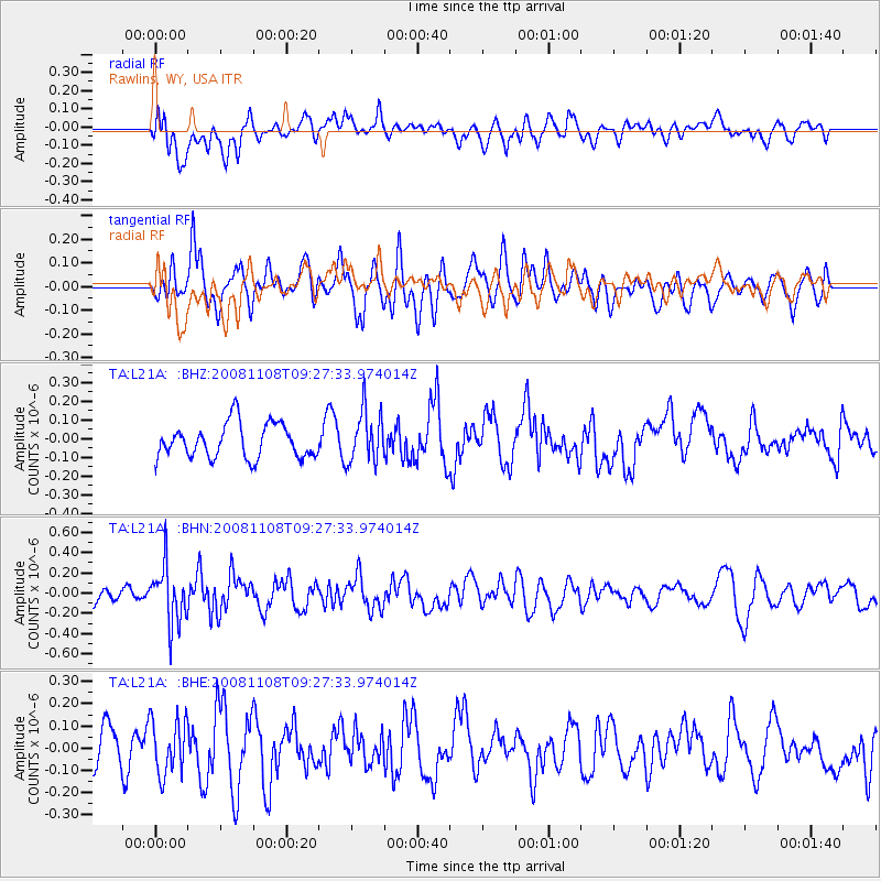
L21A Rawlins, WY, USA - Earthquake Result Viewer
*The percent match for this event was below the threshold and hence no stack was calculated.
| Earthquake location: |
Tonga Islands |
| Earthquake latitude/longitude: |
-15.2/-174.2 |
| Earthquake time(UTC): |
2008/11/08 (313) 09:15:51 GMT |
| Earthquake Depth: |
140 km |
| Earthquake Magnitude: |
5.5 MW, 5.3 MB |
| Earthquake Catalog/Contributor: |
WHDF/NEIC |
|
| Network: |
TA USArray Transportable Network (new EarthScope stations) |
| Station: |
L21A Rawlins, WY, USA |
| Lat/Lon: |
41.96 N/107.37 W |
| Elevation: |
2065 m |
|
| Distance: |
83.7 deg |
| Az: |
43.617 deg |
| Baz: |
243.246 deg |
| Ray Param: |
$rayparam |
*The percent match for this event was below the threshold and hence was not used in the summary stack. |
|
| Radial Match: |
44.997368 % |
| Radial Bump: |
400 |
| Transverse Match: |
53.09521 % |
| Transverse Bump: |
400 |
| SOD ConfigId: |
2658 |
| Insert Time: |
2010-03-06 20:12:00.423 +0000 |
| GWidth: |
2.5 |
| Max Bumps: |
400 |
| Tol: |
0.001 |
|
Signal To Noise
| Channel | StoN | STA | LTA |
| TA:L21A: :BHN:20081108T09:27:33.974014Z | 3.1607003 | 2.832863E-7 | 8.9627704E-8 |
| TA:L21A: :BHE:20081108T09:27:33.974014Z | 1.713117 | 1.2368942E-7 | 7.220138E-8 |
| TA:L21A: :BHZ:20081108T09:27:33.974014Z | 1.5038384 | 1.3712793E-7 | 9.1185285E-8 |
| Arrivals |
| Ps | |
| PpPs | |
| PsPs/PpSs | |


