You are here: Home > Network List > TA - USArray Transportable Network (new EarthScope stations) Stations List
> Station L21A Rawlins, WY, USA > Earthquake Result Viewer
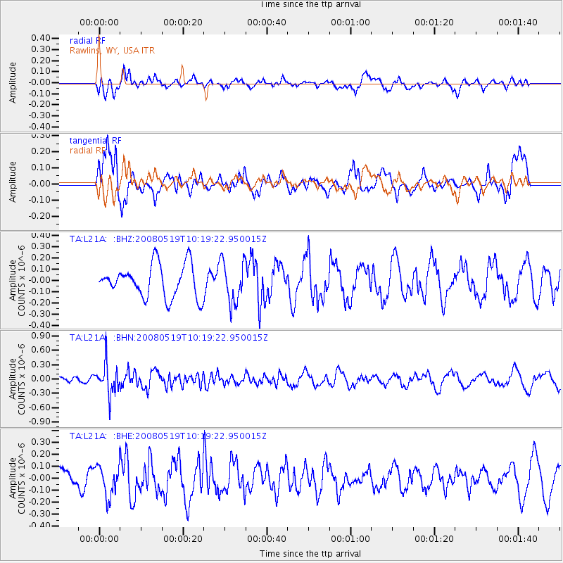
L21A Rawlins, WY, USA - Earthquake Result Viewer
*The percent match for this event was below the threshold and hence no stack was calculated.
| Earthquake location: |
E. Russia-N.E. China Border Reg. |
| Earthquake latitude/longitude: |
42.5/131.9 |
| Earthquake time(UTC): |
2008/05/19 (140) 10:08:36 GMT |
| Earthquake Depth: |
513 km |
| Earthquake Magnitude: |
5.7 MW, 5.4 MB, 5.6 MW |
| Earthquake Catalog/Contributor: |
WHDF/NEIC |
|
| Network: |
TA USArray Transportable Network (new EarthScope stations) |
| Station: |
L21A Rawlins, WY, USA |
| Lat/Lon: |
41.96 N/107.37 W |
| Elevation: |
2065 m |
|
| Distance: |
80.4 deg |
| Az: |
40.537 deg |
| Baz: |
319.875 deg |
| Ray Param: |
$rayparam |
*The percent match for this event was below the threshold and hence was not used in the summary stack. |
|
| Radial Match: |
50.964703 % |
| Radial Bump: |
400 |
| Transverse Match: |
60.813362 % |
| Transverse Bump: |
381 |
| SOD ConfigId: |
2504 |
| Insert Time: |
2010-03-06 20:12:19.989 +0000 |
| GWidth: |
2.5 |
| Max Bumps: |
400 |
| Tol: |
0.001 |
|
Signal To Noise
| Channel | StoN | STA | LTA |
| TA:L21A: :BHN:20080519T10:19:22.950015Z | 3.4436555 | 3.3017164E-7 | 9.587825E-8 |
| TA:L21A: :BHE:20080519T10:19:22.950015Z | 0.9709726 | 1.305777E-7 | 1.3448134E-7 |
| TA:L21A: :BHZ:20080519T10:19:22.950015Z | 1.2841771 | 1.8524524E-7 | 1.442521E-7 |
| Arrivals |
| Ps | |
| PpPs | |
| PsPs/PpSs | |


