You are here: Home > Network List > TS - TERRAscope (Southern California Seismic Network) Stations List
> Station CWC Cottonwood Creek Canyon, California, USA > Earthquake Result Viewer
CWC Cottonwood Creek Canyon, California, USA - Earthquake Result Viewer
| Earthquake location: |
South Of Kermadec Islands |
| Earthquake latitude/longitude: |
-32.1/179.8 |
| Earthquake time(UTC): |
1997/05/25 (145) 23:22:33 GMT |
| Earthquake Depth: |
333 km |
| Earthquake Magnitude: |
6.2 MB, 7.1 UNKNOWN, 7.0 MW |
| Earthquake Catalog/Contributor: |
WHDF/NEIC |
|
| Network: |
TS TERRAscope (Southern California Seismic Network) |
| Station: |
CWC Cottonwood Creek Canyon, California, USA |
| Lat/Lon: |
36.44 N/118.08 W |
| Elevation: |
1553 m |
|
| Distance: |
89.6 deg |
| Az: |
45.468 deg |
| Baz: |
228.605 deg |
| Ray Param: |
0.04165397 |
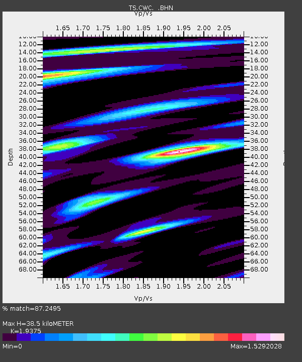
| Estimated Moho Depth: |
38.5 km |
| Estimated Crust Vp/Vs: |
1.94 |
| Assumed Crust Vp: |
6.291 km/s |
| Estimated Crust Vs: |
3.247 km/s |
| Estimated Crust Poisson's Ratio: |
0.32 |
|
| Radial Match: |
87.2495 % |
| Radial Bump: |
400 |
| Transverse Match: |
73.78594 % |
| Transverse Bump: |
400 |
| SOD ConfigId: |
6273 |
| Insert Time: |
2010-02-26 14:05:53.917 +0000 |
| GWidth: |
2.5 |
| Max Bumps: |
400 |
| Tol: |
0.001 |
|

Signal To Noise
| Channel | StoN | STA | LTA |
| TS:CWC: :BHN:19970525T23:34:22.198022Z | 1.7300037 | 2.6642866E-7 | 1.5400467E-7 |
| TS:CWC: :BHE:19970525T23:34:22.198022Z | 0.6358534 | 4.2348103E-7 | 6.6600415E-7 |
| TS:CWC: :BHZ:19970525T23:34:22.198022Z | 3.1636655 | 3.2895724E-7 | 1.0397978E-7 |
| Arrivals |
| Ps | 5.8 SECOND |
| PpPs | 18 SECOND |
| PsPs/PpSs | 23 SECOND |


