You are here: Home > Network List > TA - USArray Transportable Network (new EarthScope stations) Stations List
> Station D25K Kavik River, AK, USA > Earthquake Result Viewer
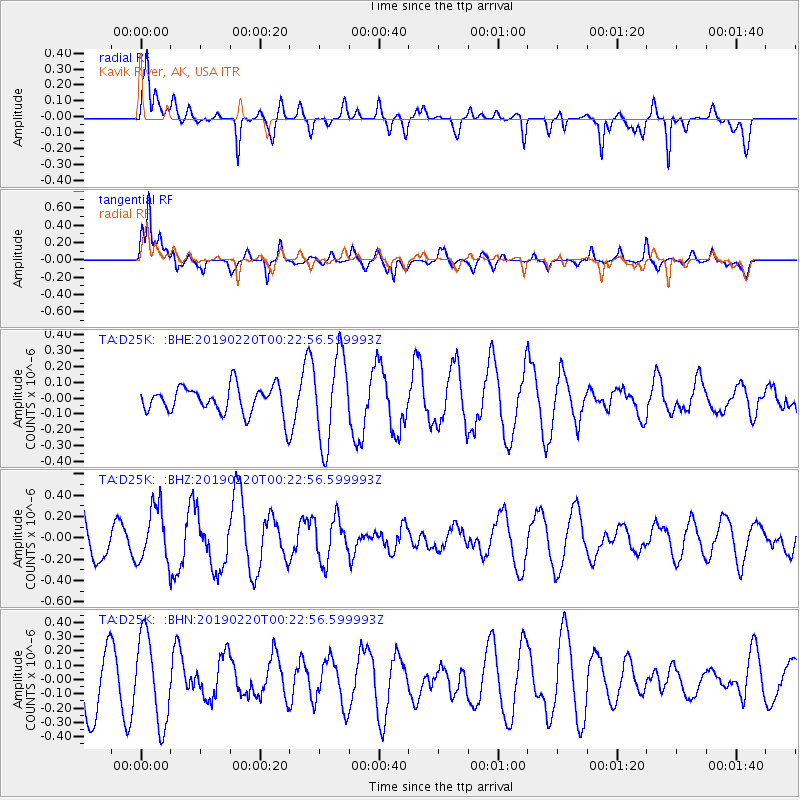
D25K Kavik River, AK, USA - Earthquake Result Viewer
*The percent match for this event was below the threshold and hence no stack was calculated.
| Earthquake location: |
Northern Molucca Sea |
| Earthquake latitude/longitude: |
0.7/126.2 |
| Earthquake time(UTC): |
2019/02/20 (051) 00:10:39 GMT |
| Earthquake Depth: |
36 km |
| Earthquake Magnitude: |
5.6 Mww |
| Earthquake Catalog/Contributor: |
NEIC PDE/us |
|
| Network: |
TA USArray Transportable Network (new EarthScope stations) |
| Station: |
D25K Kavik River, AK, USA |
| Lat/Lon: |
69.32 N/146.38 W |
| Elevation: |
770 m |
|
| Distance: |
88.4 deg |
| Az: |
20.792 deg |
| Baz: |
267.869 deg |
| Ray Param: |
$rayparam |
*The percent match for this event was below the threshold and hence was not used in the summary stack. |
|
| Radial Match: |
69.336655 % |
| Radial Bump: |
400 |
| Transverse Match: |
82.25046 % |
| Transverse Bump: |
400 |
| SOD ConfigId: |
13570011 |
| Insert Time: |
2019-05-02 13:31:08.180 +0000 |
| GWidth: |
2.5 |
| Max Bumps: |
400 |
| Tol: |
0.001 |
|
Signal To Noise
| Channel | StoN | STA | LTA |
| TA:D25K: :BHZ:20190220T00:22:56.599993Z | 1.5325515 | 2.6008584E-7 | 1.6970773E-7 |
| TA:D25K: :BHN:20190220T00:22:56.599993Z | 1.6614238 | 3.0507098E-7 | 1.836202E-7 |
| TA:D25K: :BHE:20190220T00:22:56.599993Z | 3.15036 | 2.773368E-7 | 8.803336E-8 |
| Arrivals |
| Ps | |
| PpPs | |
| PsPs/PpSs | |


