You are here: Home > Network List > TA - USArray Transportable Network (new EarthScope stations) Stations List
> Station E18K Tukpahlearik Creek, AK, USA > Earthquake Result Viewer
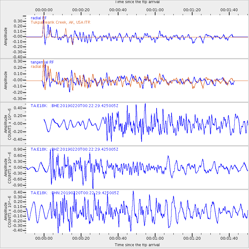
E18K Tukpahlearik Creek, AK, USA - Earthquake Result Viewer
*The percent match for this event was below the threshold and hence no stack was calculated.
| Earthquake location: |
Northern Molucca Sea |
| Earthquake latitude/longitude: |
0.7/126.2 |
| Earthquake time(UTC): |
2019/02/20 (051) 00:10:39 GMT |
| Earthquake Depth: |
36 km |
| Earthquake Magnitude: |
5.6 Mww |
| Earthquake Catalog/Contributor: |
NEIC PDE/us |
|
| Network: |
TA USArray Transportable Network (new EarthScope stations) |
| Station: |
E18K Tukpahlearik Creek, AK, USA |
| Lat/Lon: |
67.42 N/160.60 W |
| Elevation: |
297 m |
|
| Distance: |
82.9 deg |
| Az: |
21.873 deg |
| Baz: |
254.726 deg |
| Ray Param: |
$rayparam |
*The percent match for this event was below the threshold and hence was not used in the summary stack. |
|
| Radial Match: |
57.988735 % |
| Radial Bump: |
400 |
| Transverse Match: |
59.815487 % |
| Transverse Bump: |
400 |
| SOD ConfigId: |
13570011 |
| Insert Time: |
2019-05-02 13:31:08.952 +0000 |
| GWidth: |
2.5 |
| Max Bumps: |
400 |
| Tol: |
0.001 |
|
Signal To Noise
| Channel | StoN | STA | LTA |
| TA:E18K: :BHZ:20190220T00:22:29.425005Z | 5.546524 | 3.847177E-7 | 6.9361946E-8 |
| TA:E18K: :BHN:20190220T00:22:29.425005Z | 1.514861 | 1.2690641E-7 | 8.37743E-8 |
| TA:E18K: :BHE:20190220T00:22:29.425005Z | 1.9416842 | 1.613432E-7 | 8.3094456E-8 |
| Arrivals |
| Ps | |
| PpPs | |
| PsPs/PpSs | |


