You are here: Home > Network List > TA - USArray Transportable Network (new EarthScope stations) Stations List
> Station P08K Saint George Island, AK, USA > Earthquake Result Viewer
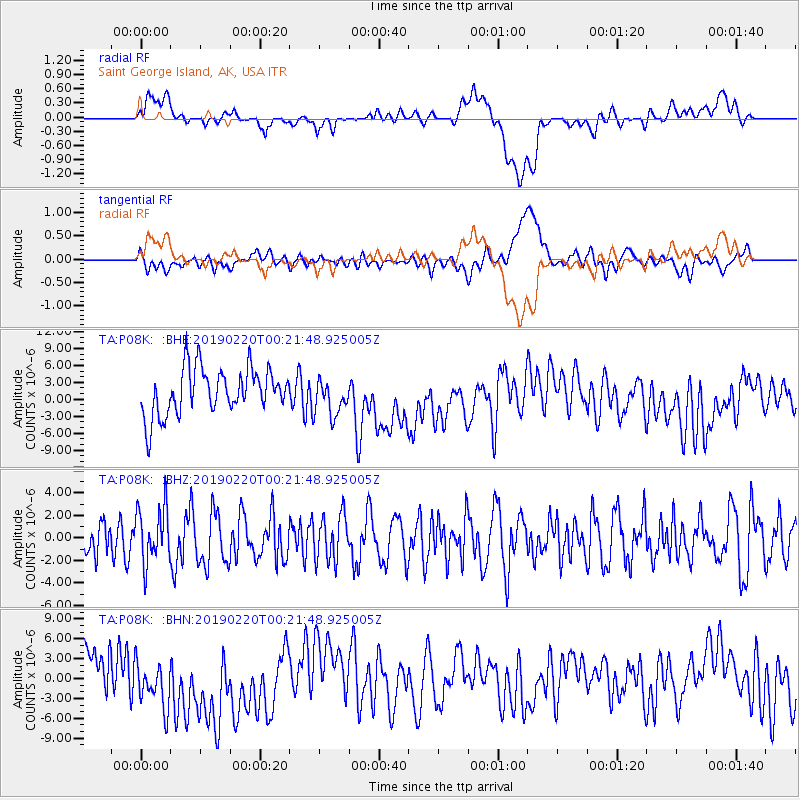
P08K Saint George Island, AK, USA - Earthquake Result Viewer
*The percent match for this event was below the threshold and hence no stack was calculated.
| Earthquake location: |
Northern Molucca Sea |
| Earthquake latitude/longitude: |
0.7/126.2 |
| Earthquake time(UTC): |
2019/02/20 (051) 00:10:39 GMT |
| Earthquake Depth: |
36 km |
| Earthquake Magnitude: |
5.6 Mww |
| Earthquake Catalog/Contributor: |
NEIC PDE/us |
|
| Network: |
TA USArray Transportable Network (new EarthScope stations) |
| Station: |
P08K Saint George Island, AK, USA |
| Lat/Lon: |
56.60 N/169.55 W |
| Elevation: |
36 m |
|
| Distance: |
75.5 deg |
| Az: |
30.974 deg |
| Baz: |
248.513 deg |
| Ray Param: |
$rayparam |
*The percent match for this event was below the threshold and hence was not used in the summary stack. |
|
| Radial Match: |
31.893045 % |
| Radial Bump: |
400 |
| Transverse Match: |
30.283033 % |
| Transverse Bump: |
400 |
| SOD ConfigId: |
13570011 |
| Insert Time: |
2019-05-02 13:31:43.024 +0000 |
| GWidth: |
2.5 |
| Max Bumps: |
400 |
| Tol: |
0.001 |
|
Signal To Noise
| Channel | StoN | STA | LTA |
| TA:P08K: :BHZ:20190220T00:21:48.925005Z | 1.2589103 | 2.469066E-6 | 1.9612726E-6 |
| TA:P08K: :BHN:20190220T00:21:48.925005Z | 0.7758431 | 4.163715E-6 | 5.366697E-6 |
| TA:P08K: :BHE:20190220T00:21:48.925005Z | 0.78765357 | 3.2121936E-6 | 4.078181E-6 |
| Arrivals |
| Ps | |
| PpPs | |
| PsPs/PpSs | |


