You are here: Home > Network List > TA - USArray Transportable Network (new EarthScope stations) Stations List
> Station L21A Rawlins, WY, USA > Earthquake Result Viewer
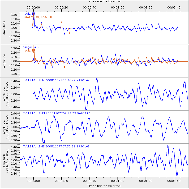
L21A Rawlins, WY, USA - Earthquake Result Viewer
*The percent match for this event was below the threshold and hence no stack was calculated.
| Earthquake location: |
Vanuatu Islands |
| Earthquake latitude/longitude: |
-14.8/168.0 |
| Earthquake time(UTC): |
2008/11/07 (312) 07:19:35 GMT |
| Earthquake Depth: |
13 km |
| Earthquake Magnitude: |
6.0 MB, 6.3 MS, 6.4 MW, 6.4 MW |
| Earthquake Catalog/Contributor: |
WHDF/NEIC |
|
| Network: |
TA USArray Transportable Network (new EarthScope stations) |
| Station: |
L21A Rawlins, WY, USA |
| Lat/Lon: |
41.96 N/107.37 W |
| Elevation: |
2065 m |
|
| Distance: |
95.8 deg |
| Az: |
48.274 deg |
| Baz: |
255.426 deg |
| Ray Param: |
$rayparam |
*The percent match for this event was below the threshold and hence was not used in the summary stack. |
|
| Radial Match: |
72.54334 % |
| Radial Bump: |
400 |
| Transverse Match: |
70.43326 % |
| Transverse Bump: |
400 |
| SOD ConfigId: |
2658 |
| Insert Time: |
2010-03-06 20:12:31.590 +0000 |
| GWidth: |
2.5 |
| Max Bumps: |
400 |
| Tol: |
0.001 |
|
Signal To Noise
| Channel | StoN | STA | LTA |
| TA:L21A: :BHN:20081107T07:32:29.949014Z | 4.059951 | 2.5659017E-7 | 6.320032E-8 |
| TA:L21A: :BHE:20081107T07:32:29.949014Z | 0.9267734 | 8.5308095E-8 | 9.204849E-8 |
| TA:L21A: :BHZ:20081107T07:32:29.949014Z | 1.3720006 | 1.4942954E-7 | 1.0891361E-7 |
| Arrivals |
| Ps | |
| PpPs | |
| PsPs/PpSs | |


