You are here: Home > Network List > CI - Caltech Regional Seismic Network Stations List
> Station MPM Manuel Prospect Mine, California, USA > Earthquake Result Viewer
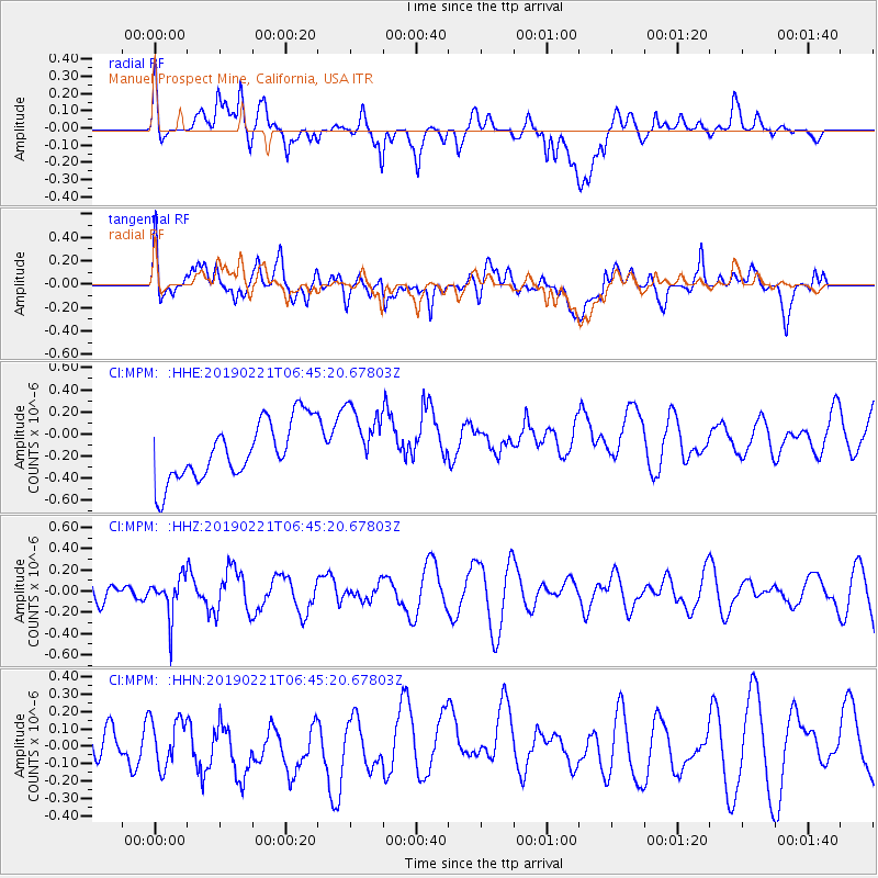
MPM Manuel Prospect Mine, California, USA - Earthquake Result Viewer
*The percent match for this event was below the threshold and hence no stack was calculated.
| Earthquake location: |
Fiji Islands Region |
| Earthquake latitude/longitude: |
-20.9/-178.8 |
| Earthquake time(UTC): |
2019/02/21 (052) 06:34:39 GMT |
| Earthquake Depth: |
617 km |
| Earthquake Magnitude: |
5.6 Mww |
| Earthquake Catalog/Contributor: |
NEIC PDE/us |
|
| Network: |
CI Caltech Regional Seismic Network |
| Station: |
MPM Manuel Prospect Mine, California, USA |
| Lat/Lon: |
36.06 N/117.49 W |
| Elevation: |
185 m |
|
| Distance: |
81.0 deg |
| Az: |
46.04 deg |
| Baz: |
236.183 deg |
| Ray Param: |
$rayparam |
*The percent match for this event was below the threshold and hence was not used in the summary stack. |
|
| Radial Match: |
34.505554 % |
| Radial Bump: |
400 |
| Transverse Match: |
46.45042 % |
| Transverse Bump: |
400 |
| SOD ConfigId: |
13570011 |
| Insert Time: |
2019-05-02 13:36:10.052 +0000 |
| GWidth: |
2.5 |
| Max Bumps: |
400 |
| Tol: |
0.001 |
|
Signal To Noise
| Channel | StoN | STA | LTA |
| CI:MPM: :HHZ:20190221T06:45:20.67803Z | 1.6108632 | 1.8858225E-7 | 1.17069064E-7 |
| CI:MPM: :HHN:20190221T06:45:20.67803Z | 1.3065689 | 1.4293272E-7 | 1.0939547E-7 |
| CI:MPM: :HHE:20190221T06:45:20.67803Z | 1.1545641 | 3.053486E-7 | 2.6447088E-7 |
| Arrivals |
| Ps | |
| PpPs | |
| PsPs/PpSs | |


