You are here: Home > Network List > TS - TERRAscope (Southern California Seismic Network) Stations List
> Station CWC Cottonwood Creek Canyon, California, USA > Earthquake Result Viewer
CWC Cottonwood Creek Canyon, California, USA - Earthquake Result Viewer
| Earthquake location: |
Near Coast Of Central Chile |
| Earthquake latitude/longitude: |
-30.1/-71.9 |
| Earthquake time(UTC): |
1997/07/06 (187) 09:54:00 GMT |
| Earthquake Depth: |
19 km |
| Earthquake Magnitude: |
5.8 MB, 6.5 MS, 6.8 UNKNOWN, 6.4 ME |
| Earthquake Catalog/Contributor: |
WHDF/NEIC |
|
| Network: |
TS TERRAscope (Southern California Seismic Network) |
| Station: |
CWC Cottonwood Creek Canyon, California, USA |
| Lat/Lon: |
36.44 N/118.08 W |
| Elevation: |
1553 m |
|
| Distance: |
79.1 deg |
| Az: |
323.645 deg |
| Baz: |
140.407 deg |
| Ray Param: |
0.04917549 |
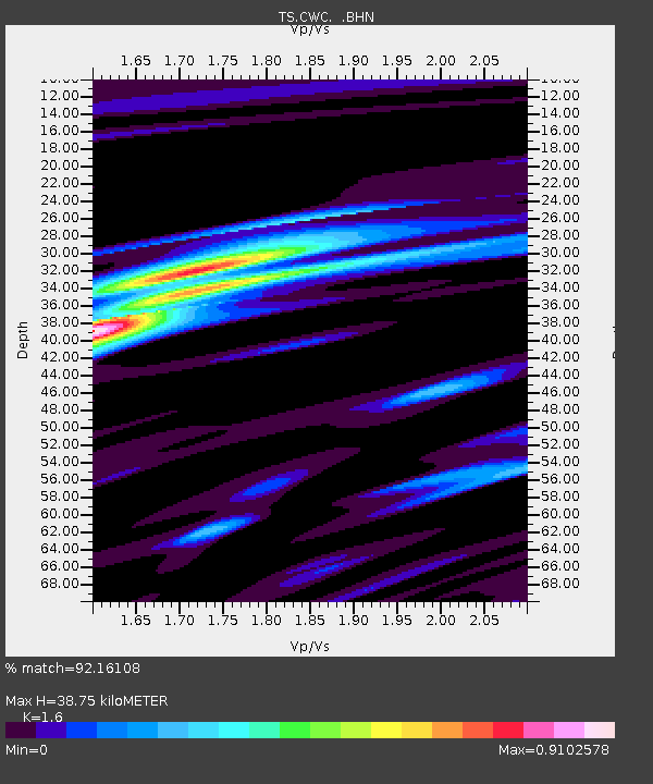
| Estimated Moho Depth: |
38.75 km |
| Estimated Crust Vp/Vs: |
1.60 |
| Assumed Crust Vp: |
6.291 km/s |
| Estimated Crust Vs: |
3.932 km/s |
| Estimated Crust Poisson's Ratio: |
0.18 |
|
| Radial Match: |
92.16108 % |
| Radial Bump: |
400 |
| Transverse Match: |
82.02199 % |
| Transverse Bump: |
400 |
| SOD ConfigId: |
6273 |
| Insert Time: |
2010-02-26 14:05:55.644 +0000 |
| GWidth: |
2.5 |
| Max Bumps: |
400 |
| Tol: |
0.001 |
|
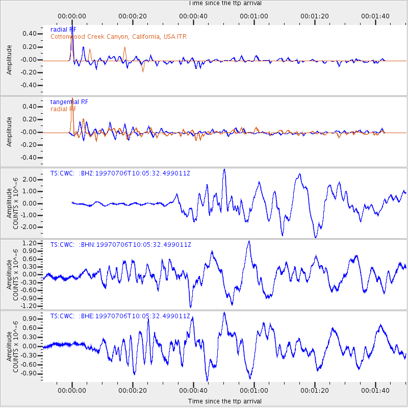
Signal To Noise
| Channel | StoN | STA | LTA |
| TS:CWC: :BHN:19970706T10:05:32.499011Z | 1.3695924 | 1.1468029E-7 | 8.373315E-8 |
| TS:CWC: :BHE:19970706T10:05:32.499011Z | 0.7432003 | 5.2973892E-8 | 7.127809E-8 |
| TS:CWC: :BHZ:19970706T10:05:32.499011Z | 3.9367862 | 3.2078074E-7 | 8.1482895E-8 |
| Arrivals |
| Ps | 3.8 SECOND |
| PpPs | 16 SECOND |
| PsPs/PpSs | 19 SECOND |


