You are here: Home > Network List > TA - USArray Transportable Network (new EarthScope stations) Stations List
> Station 627A Terlingua Ranch, Terlingua, TX, USA > Earthquake Result Viewer
627A Terlingua Ranch, Terlingua, TX, USA - Earthquake Result Viewer
| Earthquake location: |
Easter Island Region |
| Earthquake latitude/longitude: |
-29.1/-112.3 |
| Earthquake time(UTC): |
2009/09/17 (260) 23:21:38 GMT |
| Earthquake Depth: |
10 km |
| Earthquake Magnitude: |
5.7 MB, 6.0 MS, 6.2 MW, 6.2 MW |
| Earthquake Catalog/Contributor: |
WHDF/NEIC |
|
| Network: |
TA USArray Transportable Network (new EarthScope stations) |
| Station: |
627A Terlingua Ranch, Terlingua, TX, USA |
| Lat/Lon: |
29.45 N/103.39 W |
| Elevation: |
1163 m |
|
| Distance: |
58.9 deg |
| Az: |
9.046 deg |
| Baz: |
189.074 deg |
| Ray Param: |
0.062554546 |
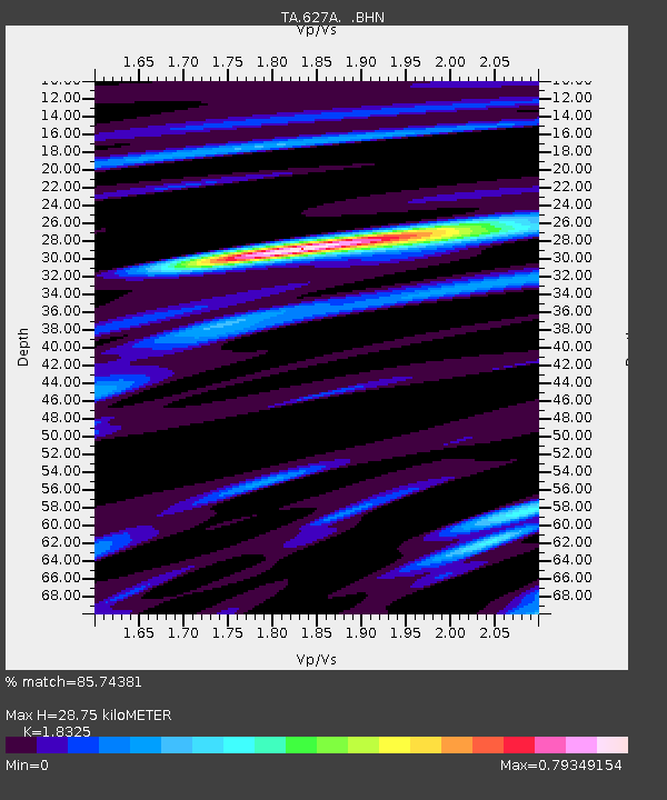
| Estimated Moho Depth: |
28.75 km |
| Estimated Crust Vp/Vs: |
1.83 |
| Assumed Crust Vp: |
6.419 km/s |
| Estimated Crust Vs: |
3.503 km/s |
| Estimated Crust Poisson's Ratio: |
0.29 |
|
| Radial Match: |
85.74381 % |
| Radial Bump: |
379 |
| Transverse Match: |
64.366 % |
| Transverse Bump: |
400 |
| SOD ConfigId: |
2622 |
| Insert Time: |
2010-03-06 20:13:45.356 +0000 |
| GWidth: |
2.5 |
| Max Bumps: |
400 |
| Tol: |
0.001 |
|
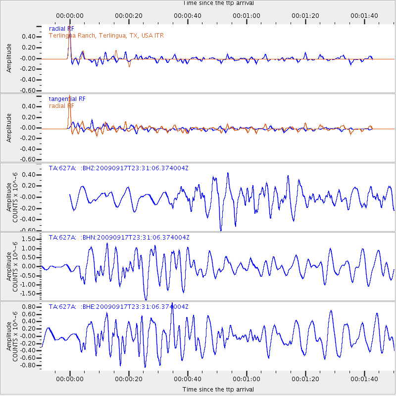
Signal To Noise
| Channel | StoN | STA | LTA |
| TA:627A: :BHN:20090917T23:31:06.374004Z | 1.7575488 | 3.3018208E-7 | 1.878651E-7 |
| TA:627A: :BHE:20090917T23:31:06.374004Z | 1.0510678 | 1.5387704E-7 | 1.4640067E-7 |
| TA:627A: :BHZ:20090917T23:31:06.374004Z | 0.7341507 | 8.464931E-8 | 1.1530236E-7 |
| Arrivals |
| Ps | 3.9 SECOND |
| PpPs | 12 SECOND |
| PsPs/PpSs | 16 SECOND |


