You are here: Home > Network List > AU - Australian Seismological Centre Stations List
> Station XMIS Christmas Island Grants Well > Earthquake Result Viewer
XMIS Christmas Island Grants Well - Earthquake Result Viewer
| Earthquake location: |
Hokkaido, Japan Region |
| Earthquake latitude/longitude: |
42.8/141.9 |
| Earthquake time(UTC): |
2019/02/21 (052) 12:22:41 GMT |
| Earthquake Depth: |
41 km |
| Earthquake Magnitude: |
5.5 Mww |
| Earthquake Catalog/Contributor: |
NEIC PDE/us |
|
| Network: |
AU Australian Seismological Centre |
| Station: |
XMIS Christmas Island Grants Well |
| Lat/Lon: |
10.48 S/105.65 E |
| Elevation: |
210 m |
|
| Distance: |
62.6 deg |
| Az: |
221.001 deg |
| Baz: |
29.397 deg |
| Ray Param: |
0.060070474 |
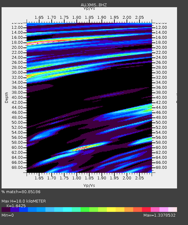
| Estimated Moho Depth: |
18.0 km |
| Estimated Crust Vp/Vs: |
1.64 |
| Assumed Crust Vp: |
4.157 km/s |
| Estimated Crust Vs: |
2.531 km/s |
| Estimated Crust Poisson's Ratio: |
0.21 |
|
| Radial Match: |
80.85186 % |
| Radial Bump: |
400 |
| Transverse Match: |
61.761547 % |
| Transverse Bump: |
400 |
| SOD ConfigId: |
13570011 |
| Insert Time: |
2019-05-02 13:41:49.730 +0000 |
| GWidth: |
2.5 |
| Max Bumps: |
400 |
| Tol: |
0.001 |
|

Signal To Noise
| Channel | StoN | STA | LTA |
| AU:XMIS: :BHZ:20190221T12:32:30.744021Z | 2.3071241 | 6.832233E-7 | 2.961363E-7 |
| AU:XMIS: :BHN:20190221T12:32:30.744021Z | 1.6874393 | 3.6665983E-7 | 2.1728772E-7 |
| AU:XMIS: :BHE:20190221T12:32:30.744021Z | 0.65155154 | 1.5420991E-7 | 2.3668107E-7 |
| Arrivals |
| Ps | 2.8 SECOND |
| PpPs | 11 SECOND |
| PsPs/PpSs | 14 SECOND |


