You are here: Home > Network List > TA - USArray Transportable Network (new EarthScope stations) Stations List
> Station 627A Terlingua Ranch, Terlingua, TX, USA > Earthquake Result Viewer
627A Terlingua Ranch, Terlingua, TX, USA - Earthquake Result Viewer
| Earthquake location: |
Kermadec Islands Region |
| Earthquake latitude/longitude: |
-31.2/-176.9 |
| Earthquake time(UTC): |
2008/12/09 (344) 06:23:59 GMT |
| Earthquake Depth: |
18 km |
| Earthquake Magnitude: |
6.2 MB, 6.7 MS, 6.8 MW, 6.7 MW |
| Earthquake Catalog/Contributor: |
WHDF/NEIC |
|
| Network: |
TA USArray Transportable Network (new EarthScope stations) |
| Station: |
627A Terlingua Ranch, Terlingua, TX, USA |
| Lat/Lon: |
29.45 N/103.39 W |
| Elevation: |
1163 m |
|
| Distance: |
92.3 deg |
| Az: |
56.835 deg |
| Baz: |
235.302 deg |
| Ray Param: |
0.041471776 |
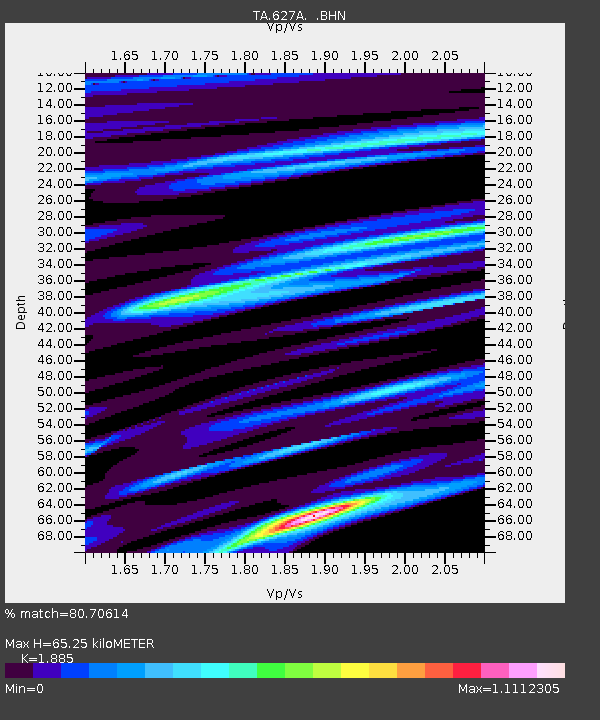
| Estimated Moho Depth: |
65.25 km |
| Estimated Crust Vp/Vs: |
1.88 |
| Assumed Crust Vp: |
6.419 km/s |
| Estimated Crust Vs: |
3.405 km/s |
| Estimated Crust Poisson's Ratio: |
0.30 |
|
| Radial Match: |
80.70614 % |
| Radial Bump: |
400 |
| Transverse Match: |
60.79556 % |
| Transverse Bump: |
379 |
| SOD ConfigId: |
2658 |
| Insert Time: |
2010-03-06 20:14:10.916 +0000 |
| GWidth: |
2.5 |
| Max Bumps: |
400 |
| Tol: |
0.001 |
|

Signal To Noise
| Channel | StoN | STA | LTA |
| TA:627A: :BHN:20081209T06:36:37.275024Z | 5.8395605 | 1.5485386E-6 | 2.651807E-7 |
| TA:627A: :BHE:20081209T06:36:37.275024Z | 0.9696994 | 4.3080823E-7 | 4.442699E-7 |
| TA:627A: :BHZ:20081209T06:36:37.275024Z | 1.9771849 | 5.511497E-7 | 2.7875475E-7 |
| Arrivals |
| Ps | 9.2 SECOND |
| PpPs | 29 SECOND |
| PsPs/PpSs | 38 SECOND |


