You are here: Home > Network List > TA - USArray Transportable Network (new EarthScope stations) Stations List
> Station 627A Terlingua Ranch, Terlingua, TX, USA > Earthquake Result Viewer
627A Terlingua Ranch, Terlingua, TX, USA - Earthquake Result Viewer
| Earthquake location: |
Rat Islands, Aleutian Islands |
| Earthquake latitude/longitude: |
50.4/177.0 |
| Earthquake time(UTC): |
2009/07/06 (187) 14:53:12 GMT |
| Earthquake Depth: |
22 km |
| Earthquake Magnitude: |
6.0 MB, 5.8 MS, 6.1 MW, 6.0 MW |
| Earthquake Catalog/Contributor: |
WHDF/NEIC |
|
| Network: |
TA USArray Transportable Network (new EarthScope stations) |
| Station: |
627A Terlingua Ranch, Terlingua, TX, USA |
| Lat/Lon: |
29.45 N/103.39 W |
| Elevation: |
1163 m |
|
| Distance: |
61.5 deg |
| Az: |
77.383 deg |
| Baz: |
314.314 deg |
| Ray Param: |
0.06078414 |
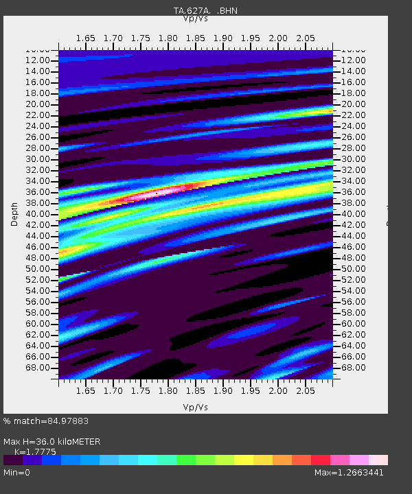
| Estimated Moho Depth: |
36.0 km |
| Estimated Crust Vp/Vs: |
1.78 |
| Assumed Crust Vp: |
6.419 km/s |
| Estimated Crust Vs: |
3.611 km/s |
| Estimated Crust Poisson's Ratio: |
0.27 |
|
| Radial Match: |
84.97883 % |
| Radial Bump: |
400 |
| Transverse Match: |
75.37847 % |
| Transverse Bump: |
400 |
| SOD ConfigId: |
2648 |
| Insert Time: |
2010-03-06 20:14:21.903 +0000 |
| GWidth: |
2.5 |
| Max Bumps: |
400 |
| Tol: |
0.001 |
|
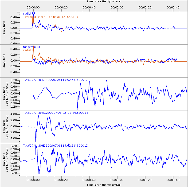
Signal To Noise
| Channel | StoN | STA | LTA |
| TA:627A: :BHN:20090706T15:02:56.50001Z | 8.052956 | 2.088825E-6 | 2.5938616E-7 |
| TA:627A: :BHE:20090706T15:02:56.50001Z | 9.949359 | 7.6777513E-7 | 7.71683E-8 |
| TA:627A: :BHZ:20090706T15:02:56.50001Z | 1.799033 | 5.5515886E-7 | 3.0858737E-7 |
| Arrivals |
| Ps | 4.6 SECOND |
| PpPs | 15 SECOND |
| PsPs/PpSs | 19 SECOND |


