You are here: Home > Network List > TA - USArray Transportable Network (new EarthScope stations) Stations List
> Station 627A Terlingua Ranch, Terlingua, TX, USA > Earthquake Result Viewer
627A Terlingua Ranch, Terlingua, TX, USA - Earthquake Result Viewer

| Earthquake location: |
Baffin Bay |
| Earthquake latitude/longitude: |
75.4/-72.5 |
| Earthquake time(UTC): |
2009/07/07 (188) 19:11:46 GMT |
| Earthquake Depth: |
19 km |
| Earthquake Magnitude: |
5.9 MB, 5.7 MS, 6.1 MW, 6.0 MW |
| Earthquake Catalog/Contributor: |
WHDF/NEIC |
|
| Network: |
TA USArray Transportable Network (new EarthScope stations) |
| Station: |
627A Terlingua Ranch, Terlingua, TX, USA |
| Lat/Lon: |
29.45 N/103.39 W |
| Elevation: |
1163 m |
|
| Distance: |
48.4 deg |
| Az: |
216.817 deg |
| Baz: |
10.07 deg |
| Ray Param: |
0.06934107 |
| Estimated Moho Depth: |
12.5 km |
| Estimated Crust Vp/Vs: |
1.60 |
| Assumed Crust Vp: |
6.419 km/s |
| Estimated Crust Vs: |
4.012 km/s |
| Estimated Crust Poisson's Ratio: |
0.18 |
|
| Radial Match: |
88.93563 % |
| Radial Bump: |
400 |
| Transverse Match: |
74.837906 % |
| Transverse Bump: |
400 |
| SOD ConfigId: |
2648 |
| Insert Time: |
2010-03-06 20:14:24.094 +0000 |
| GWidth: |
2.5 |
| Max Bumps: |
400 |
| Tol: |
0.001 |
|
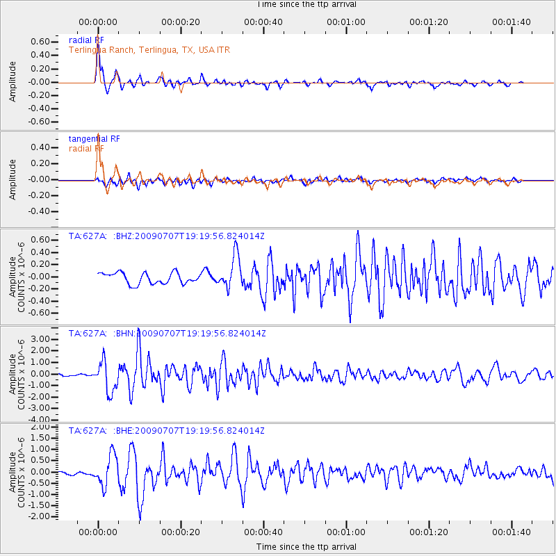
Signal To Noise
| Channel | StoN | STA | LTA |
| TA:627A: :BHN:20090707T19:19:56.824014Z | 11.685734 | 1.3451017E-6 | 1.1510631E-7 |
| TA:627A: :BHE:20090707T19:19:56.824014Z | 8.255344 | 7.0225116E-7 | 8.506624E-8 |
| TA:627A: :BHZ:20090707T19:19:56.824014Z | 3.0994072 | 2.7965345E-7 | 9.022804E-8 |
| Arrivals |
| Ps | 1.2 SECOND |
| PpPs | 4.7 SECOND |
| PsPs/PpSs | 6.0 SECOND |


