You are here: Home > Network List > TA - USArray Transportable Network (new EarthScope stations) Stations List
> Station 627A Terlingua Ranch, Terlingua, TX, USA > Earthquake Result Viewer
627A Terlingua Ranch, Terlingua, TX, USA - Earthquake Result Viewer
| Earthquake location: |
Kodiak Island Region, Alaska |
| Earthquake latitude/longitude: |
56.4/-152.4 |
| Earthquake time(UTC): |
2009/05/16 (136) 18:22:25 GMT |
| Earthquake Depth: |
9.7 km |
| Earthquake Magnitude: |
5.9 MS, 5.4 MB, 5.9 MW, 5.8 MW |
| Earthquake Catalog/Contributor: |
WHDF/NEIC |
|
| Network: |
TA USArray Transportable Network (new EarthScope stations) |
| Station: |
627A Terlingua Ranch, Terlingua, TX, USA |
| Lat/Lon: |
29.45 N/103.39 W |
| Elevation: |
1163 m |
|
| Distance: |
43.6 deg |
| Az: |
107.186 deg |
| Baz: |
322.523 deg |
| Ray Param: |
0.072460055 |
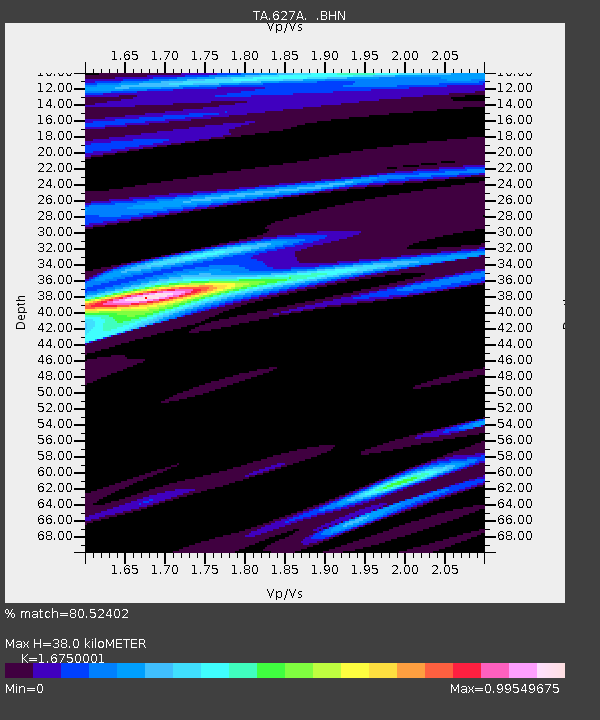
| Estimated Moho Depth: |
38.0 km |
| Estimated Crust Vp/Vs: |
1.68 |
| Assumed Crust Vp: |
6.419 km/s |
| Estimated Crust Vs: |
3.832 km/s |
| Estimated Crust Poisson's Ratio: |
0.22 |
|
| Radial Match: |
80.52402 % |
| Radial Bump: |
400 |
| Transverse Match: |
58.389713 % |
| Transverse Bump: |
400 |
| SOD ConfigId: |
2760 |
| Insert Time: |
2010-03-06 20:14:35.672 +0000 |
| GWidth: |
2.5 |
| Max Bumps: |
400 |
| Tol: |
0.001 |
|
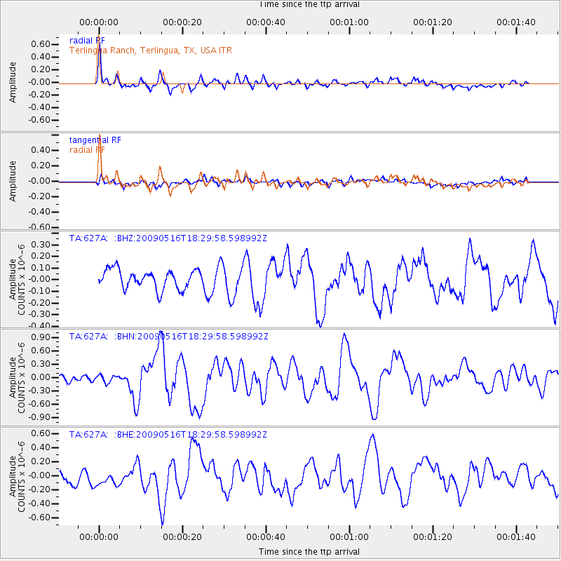
Signal To Noise
| Channel | StoN | STA | LTA |
| TA:627A: :BHN:20090516T18:29:58.598992Z | 1.1114621 | 7.974461E-8 | 7.174748E-8 |
| TA:627A: :BHE:20090516T18:29:58.598992Z | 1.2038296 | 1.3446301E-7 | 1.1169604E-7 |
| TA:627A: :BHZ:20090516T18:29:58.598992Z | 1.8141223 | 1.4409729E-7 | 7.943085E-8 |
| Arrivals |
| Ps | 4.3 SECOND |
| PpPs | 15 SECOND |
| PsPs/PpSs | 19 SECOND |


