You are here: Home > Network List > TA - USArray Transportable Network (new EarthScope stations) Stations List
> Station 627A Terlingua Ranch, Terlingua, TX, USA > Earthquake Result Viewer
627A Terlingua Ranch, Terlingua, TX, USA - Earthquake Result Viewer
| Earthquake location: |
Easter Island Region |
| Earthquake latitude/longitude: |
-28.9/-112.3 |
| Earthquake time(UTC): |
2008/05/31 (152) 23:16:04 GMT |
| Earthquake Depth: |
10 km |
| Earthquake Magnitude: |
5.5 MS, 5.4 MB, 5.8 MW, 5.8 MW |
| Earthquake Catalog/Contributor: |
WHDF/NEIC |
|
| Network: |
TA USArray Transportable Network (new EarthScope stations) |
| Station: |
627A Terlingua Ranch, Terlingua, TX, USA |
| Lat/Lon: |
29.45 N/103.39 W |
| Elevation: |
1163 m |
|
| Distance: |
58.7 deg |
| Az: |
9.059 deg |
| Baz: |
189.106 deg |
| Ray Param: |
0.06269969 |
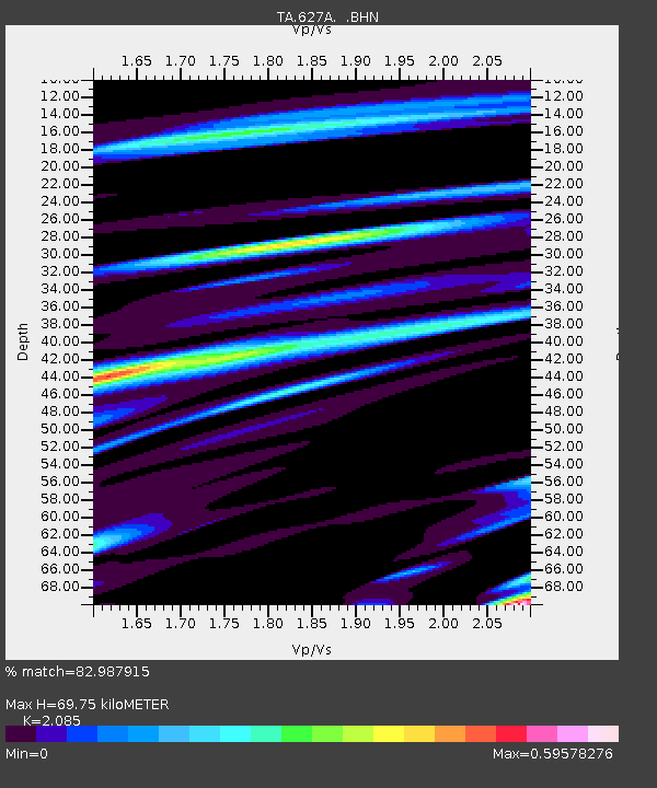
| Estimated Moho Depth: |
69.75 km |
| Estimated Crust Vp/Vs: |
2.09 |
| Assumed Crust Vp: |
6.419 km/s |
| Estimated Crust Vs: |
3.079 km/s |
| Estimated Crust Poisson's Ratio: |
0.35 |
|
| Radial Match: |
82.987915 % |
| Radial Bump: |
400 |
| Transverse Match: |
62.22656 % |
| Transverse Bump: |
400 |
| SOD ConfigId: |
2504 |
| Insert Time: |
2010-03-06 20:14:42.479 +0000 |
| GWidth: |
2.5 |
| Max Bumps: |
400 |
| Tol: |
0.001 |
|
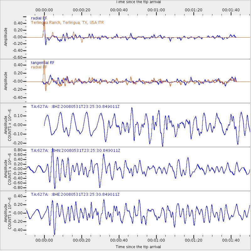
Signal To Noise
| Channel | StoN | STA | LTA |
| TA:627A: :BHN:20080531T23:25:30.849011Z | 4.7943654 | 3.5986668E-7 | 7.5060335E-8 |
| TA:627A: :BHE:20080531T23:25:30.849011Z | 2.9060836 | 1.5513025E-7 | 5.338121E-8 |
| TA:627A: :BHZ:20080531T23:25:30.849011Z | 1.2632291 | 1.01959905E-7 | 8.0713704E-8 |
| Arrivals |
| Ps | 12 SECOND |
| PpPs | 32 SECOND |
| PsPs/PpSs | 44 SECOND |


