You are here: Home > Network List > TS - TERRAscope (Southern California Seismic Network) Stations List
> Station CWC Cottonwood Creek Canyon, California, USA > Earthquake Result Viewer
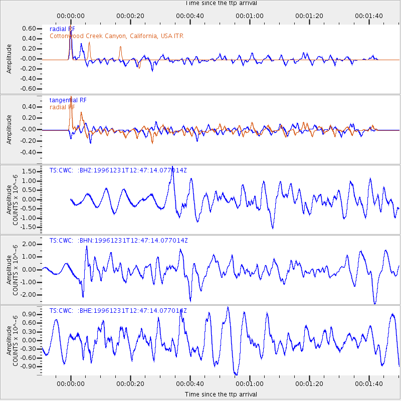
CWC Cottonwood Creek Canyon, California, USA - Earthquake Result Viewer
*The percent match for this event was below the threshold and hence no stack was calculated.
| Earthquake location: |
Mexico-Guatemala Border Region |
| Earthquake latitude/longitude: |
15.8/-93.0 |
| Earthquake time(UTC): |
1996/12/31 (366) 12:41:42 GMT |
| Earthquake Depth: |
100 km |
| Earthquake Magnitude: |
5.4 MB, 6.3 UNKNOWN, 6.3 MW |
| Earthquake Catalog/Contributor: |
WHDF/NEIC |
|
| Network: |
TS TERRAscope (Southern California Seismic Network) |
| Station: |
CWC Cottonwood Creek Canyon, California, USA |
| Lat/Lon: |
36.44 N/118.08 W |
| Elevation: |
1553 m |
|
| Distance: |
30.3 deg |
| Az: |
317.337 deg |
| Baz: |
126.009 deg |
| Ray Param: |
$rayparam |
*The percent match for this event was below the threshold and hence was not used in the summary stack. |
|
| Radial Match: |
67.277054 % |
| Radial Bump: |
367 |
| Transverse Match: |
55.756035 % |
| Transverse Bump: |
372 |
| SOD ConfigId: |
4480 |
| Insert Time: |
2010-02-26 14:05:58.278 +0000 |
| GWidth: |
2.5 |
| Max Bumps: |
400 |
| Tol: |
0.001 |
|
Signal To Noise
| Channel | StoN | STA | LTA |
| TS:CWC: :BHN:19961231T12:47:14.077014Z | 2.6167645 | 8.049288E-7 | 3.0760458E-7 |
| TS:CWC: :BHE:19961231T12:47:14.077014Z | 0.9253283 | 2.2567151E-7 | 2.4388265E-7 |
| TS:CWC: :BHZ:19961231T12:47:14.077014Z | 2.510028 | 7.8762633E-7 | 3.1379187E-7 |
| Arrivals |
| Ps | |
| PpPs | |
| PsPs/PpSs | |


