You are here: Home > Network List > TA - USArray Transportable Network (new EarthScope stations) Stations List
> Station K13K Kusilvak Mountain, AK, USA > Earthquake Result Viewer
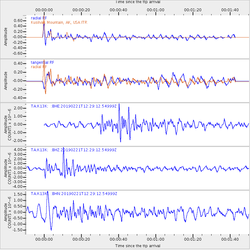
K13K Kusilvak Mountain, AK, USA - Earthquake Result Viewer
*The percent match for this event was below the threshold and hence no stack was calculated.
| Earthquake location: |
Hokkaido, Japan Region |
| Earthquake latitude/longitude: |
42.8/141.9 |
| Earthquake time(UTC): |
2019/02/21 (052) 12:22:41 GMT |
| Earthquake Depth: |
41 km |
| Earthquake Magnitude: |
5.5 Mww |
| Earthquake Catalog/Contributor: |
NEIC PDE/us |
|
| Network: |
TA USArray Transportable Network (new EarthScope stations) |
| Station: |
K13K Kusilvak Mountain, AK, USA |
| Lat/Lon: |
61.93 N/164.66 W |
| Elevation: |
204 m |
|
| Distance: |
36.5 deg |
| Az: |
39.697 deg |
| Baz: |
263.593 deg |
| Ray Param: |
$rayparam |
*The percent match for this event was below the threshold and hence was not used in the summary stack. |
|
| Radial Match: |
77.780174 % |
| Radial Bump: |
400 |
| Transverse Match: |
51.794983 % |
| Transverse Bump: |
400 |
| SOD ConfigId: |
13570011 |
| Insert Time: |
2019-05-02 13:49:00.990 +0000 |
| GWidth: |
2.5 |
| Max Bumps: |
400 |
| Tol: |
0.001 |
|
Signal To Noise
| Channel | StoN | STA | LTA |
| TA:K13K: :BHZ:20190221T12:29:12.54999Z | 3.1266153 | 8.718098E-7 | 2.78835E-7 |
| TA:K13K: :BHN:20190221T12:29:12.54999Z | 2.1281009 | 9.201991E-7 | 4.324039E-7 |
| TA:K13K: :BHE:20190221T12:29:12.54999Z | 2.6241903 | 5.146411E-7 | 1.9611423E-7 |
| Arrivals |
| Ps | |
| PpPs | |
| PsPs/PpSs | |


