You are here: Home > Network List > ND - New CaleDonia Broadband Seismic Network Stations List
> Station KOUNC Koumac, New Caledonia > Earthquake Result Viewer
KOUNC Koumac, New Caledonia - Earthquake Result Viewer
| Earthquake location: |
Southeast Of Honshu, Japan |
| Earthquake latitude/longitude: |
30.5/142.1 |
| Earthquake time(UTC): |
2016/09/20 (264) 16:21:16 GMT |
| Earthquake Depth: |
10 km |
| Earthquake Magnitude: |
6.1 MWW, 6.0 MWB |
| Earthquake Catalog/Contributor: |
NEIC PDE/NEIC COMCAT |
|
| Network: |
ND New CaleDonia Broadband Seismic Network |
| Station: |
KOUNC Koumac, New Caledonia |
| Lat/Lon: |
20.55 S/164.29 E |
| Elevation: |
88 m |
|
| Distance: |
55.1 deg |
| Az: |
154.414 deg |
| Baz: |
336.572 deg |
| Ray Param: |
0.06501691 |
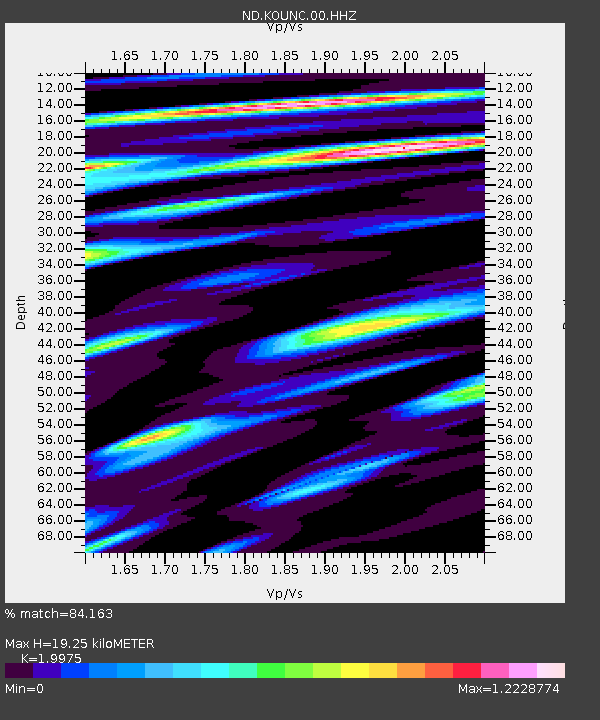
| Estimated Moho Depth: |
19.25 km |
| Estimated Crust Vp/Vs: |
2.00 |
| Assumed Crust Vp: |
5.14 km/s |
| Estimated Crust Vs: |
2.573 km/s |
| Estimated Crust Poisson's Ratio: |
0.33 |
|
| Radial Match: |
84.163 % |
| Radial Bump: |
400 |
| Transverse Match: |
77.42934 % |
| Transverse Bump: |
400 |
| SOD ConfigId: |
1634031 |
| Insert Time: |
2016-10-04 16:26:14.918 +0000 |
| GWidth: |
2.5 |
| Max Bumps: |
400 |
| Tol: |
0.001 |
|

Signal To Noise
| Channel | StoN | STA | LTA |
| ND:KOUNC:00:HHZ:20160920T16:30:18.011003Z | 3.4510055 | 1.3310645E-6 | 3.857034E-7 |
| ND:KOUNC:00:HHN:20160920T16:30:18.011003Z | 1.8841041 | 4.291026E-7 | 2.2774887E-7 |
| ND:KOUNC:00:HHE:20160920T16:30:18.011003Z | 2.3827775 | 5.1587847E-7 | 2.1650301E-7 |
| Arrivals |
| Ps | 3.8 SECOND |
| PpPs | 11 SECOND |
| PsPs/PpSs | 15 SECOND |


