You are here: Home > Network List > TA - USArray Transportable Network (new EarthScope stations) Stations List
> Station R31K City Hall, Gustavus, AK, USA > Earthquake Result Viewer
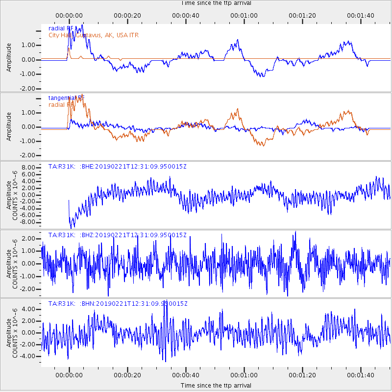
R31K City Hall, Gustavus, AK, USA - Earthquake Result Viewer
*The percent match for this event was below the threshold and hence no stack was calculated.
| Earthquake location: |
Hokkaido, Japan Region |
| Earthquake latitude/longitude: |
42.8/141.9 |
| Earthquake time(UTC): |
2019/02/21 (052) 12:22:41 GMT |
| Earthquake Depth: |
41 km |
| Earthquake Magnitude: |
5.5 Mww |
| Earthquake Catalog/Contributor: |
NEIC PDE/us |
|
| Network: |
TA USArray Transportable Network (new EarthScope stations) |
| Station: |
R31K City Hall, Gustavus, AK, USA |
| Lat/Lon: |
58.41 N/135.74 W |
| Elevation: |
15 m |
|
| Distance: |
51.1 deg |
| Az: |
42.065 deg |
| Baz: |
290.503 deg |
| Ray Param: |
$rayparam |
*The percent match for this event was below the threshold and hence was not used in the summary stack. |
|
| Radial Match: |
44.265503 % |
| Radial Bump: |
400 |
| Transverse Match: |
47.782272 % |
| Transverse Bump: |
400 |
| SOD ConfigId: |
13570011 |
| Insert Time: |
2019-05-02 13:49:27.221 +0000 |
| GWidth: |
2.5 |
| Max Bumps: |
400 |
| Tol: |
0.001 |
|
Signal To Noise
| Channel | StoN | STA | LTA |
| TA:R31K: :BHZ:20190221T12:31:09.950015Z | 1.2957973 | 8.4423453E-7 | 6.515174E-7 |
| TA:R31K: :BHN:20190221T12:31:09.950015Z | 0.95082396 | 1.8121779E-6 | 1.9059025E-6 |
| TA:R31K: :BHE:20190221T12:31:09.950015Z | 1.1533293 | 3.6918652E-6 | 3.2010505E-6 |
| Arrivals |
| Ps | |
| PpPs | |
| PsPs/PpSs | |


