You are here: Home > Network List > US - United States National Seismic Network Stations List
> Station LAO LASA Array, Montana, USA > Earthquake Result Viewer
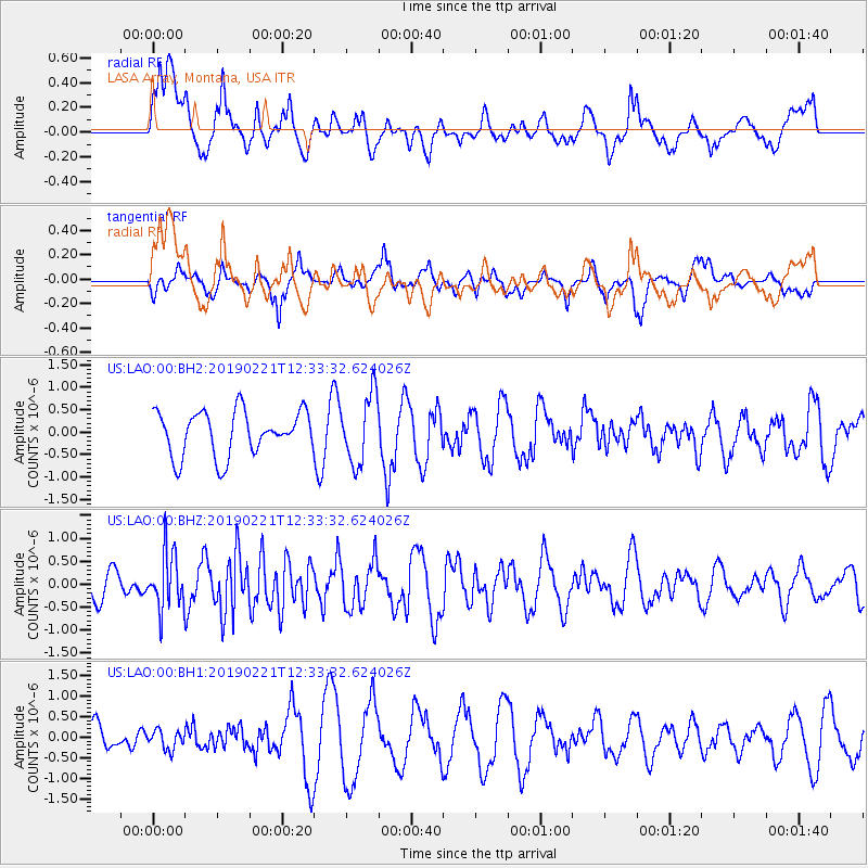
LAO LASA Array, Montana, USA - Earthquake Result Viewer
*The percent match for this event was below the threshold and hence no stack was calculated.
| Earthquake location: |
Hokkaido, Japan Region |
| Earthquake latitude/longitude: |
42.8/141.9 |
| Earthquake time(UTC): |
2019/02/21 (052) 12:22:41 GMT |
| Earthquake Depth: |
41 km |
| Earthquake Magnitude: |
5.5 Mww |
| Earthquake Catalog/Contributor: |
NEIC PDE/us |
|
| Network: |
US United States National Seismic Network |
| Station: |
LAO LASA Array, Montana, USA |
| Lat/Lon: |
46.69 N/106.22 W |
| Elevation: |
902 m |
|
| Distance: |
72.4 deg |
| Az: |
42.108 deg |
| Baz: |
314.214 deg |
| Ray Param: |
$rayparam |
*The percent match for this event was below the threshold and hence was not used in the summary stack. |
|
| Radial Match: |
45.870636 % |
| Radial Bump: |
400 |
| Transverse Match: |
45.099213 % |
| Transverse Bump: |
400 |
| SOD ConfigId: |
13570011 |
| Insert Time: |
2019-05-02 13:50:01.825 +0000 |
| GWidth: |
2.5 |
| Max Bumps: |
400 |
| Tol: |
0.001 |
|
Signal To Noise
| Channel | StoN | STA | LTA |
| US:LAO:00:BHZ:20190221T12:33:32.624026Z | 2.5325427 | 6.0758373E-7 | 2.3991055E-7 |
| US:LAO:00:BH1:20190221T12:33:32.624026Z | 0.60502565 | 2.2510123E-7 | 3.7205237E-7 |
| US:LAO:00:BH2:20190221T12:33:32.624026Z | 1.5553666 | 7.6579124E-7 | 4.9235416E-7 |
| Arrivals |
| Ps | |
| PpPs | |
| PsPs/PpSs | |


