You are here: Home > Network List > AK - Alaska Regional Network Stations List
> Station CHUM Lake Minchumina Broadband > Earthquake Result Viewer
CHUM Lake Minchumina Broadband - Earthquake Result Viewer
| Earthquake location: |
Peru-Ecuador Border Region |
| Earthquake latitude/longitude: |
-2.2/-77.0 |
| Earthquake time(UTC): |
2019/02/22 (053) 10:17:22 GMT |
| Earthquake Depth: |
132 km |
| Earthquake Magnitude: |
7.5 mww |
| Earthquake Catalog/Contributor: |
NEIC PDE/us |
|
| Network: |
AK Alaska Regional Network |
| Station: |
CHUM Lake Minchumina Broadband |
| Lat/Lon: |
63.88 N/152.31 W |
| Elevation: |
58 m |
|
| Distance: |
85.5 deg |
| Az: |
334.57 deg |
| Baz: |
104.19 deg |
| Ray Param: |
0.044412702 |
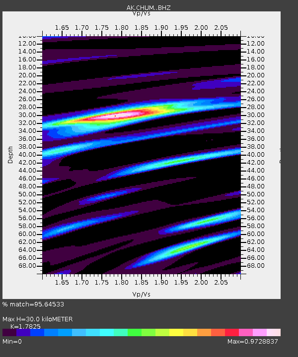
| Estimated Moho Depth: |
30.0 km |
| Estimated Crust Vp/Vs: |
1.78 |
| Assumed Crust Vp: |
6.566 km/s |
| Estimated Crust Vs: |
3.684 km/s |
| Estimated Crust Poisson's Ratio: |
0.27 |
|
| Radial Match: |
95.64533 % |
| Radial Bump: |
400 |
| Transverse Match: |
88.809685 % |
| Transverse Bump: |
400 |
| SOD ConfigId: |
13570011 |
| Insert Time: |
2019-05-02 13:52:26.230 +0000 |
| GWidth: |
2.5 |
| Max Bumps: |
400 |
| Tol: |
0.001 |
|

Signal To Noise
| Channel | StoN | STA | LTA |
| AK:CHUM: :BHZ:20190222T10:29:14.407986Z | 11.821943 | 3.084211E-6 | 2.6088867E-7 |
| AK:CHUM: :BHN:20190222T10:29:14.407986Z | 1.8125981 | 3.822508E-7 | 2.1088557E-7 |
| AK:CHUM: :BHE:20190222T10:29:14.407986Z | 3.1921737 | 1.1375832E-6 | 3.5636631E-7 |
| Arrivals |
| Ps | 3.7 SECOND |
| PpPs | 12 SECOND |
| PsPs/PpSs | 16 SECOND |


