You are here: Home > Network List > AK - Alaska Regional Network Stations List
> Station HIN Hinchinbrook, AK, USA > Earthquake Result Viewer
HIN Hinchinbrook, AK, USA - Earthquake Result Viewer
| Earthquake location: |
Peru-Ecuador Border Region |
| Earthquake latitude/longitude: |
-2.2/-77.0 |
| Earthquake time(UTC): |
2019/02/22 (053) 10:17:22 GMT |
| Earthquake Depth: |
132 km |
| Earthquake Magnitude: |
7.5 mww |
| Earthquake Catalog/Contributor: |
NEIC PDE/us |
|
| Network: |
AK Alaska Regional Network |
| Station: |
HIN Hinchinbrook, AK, USA |
| Lat/Lon: |
60.40 N/146.50 W |
| Elevation: |
623 m |
|
| Distance: |
81.9 deg |
| Az: |
331.986 deg |
| Baz: |
109.04 deg |
| Ray Param: |
0.046954468 |
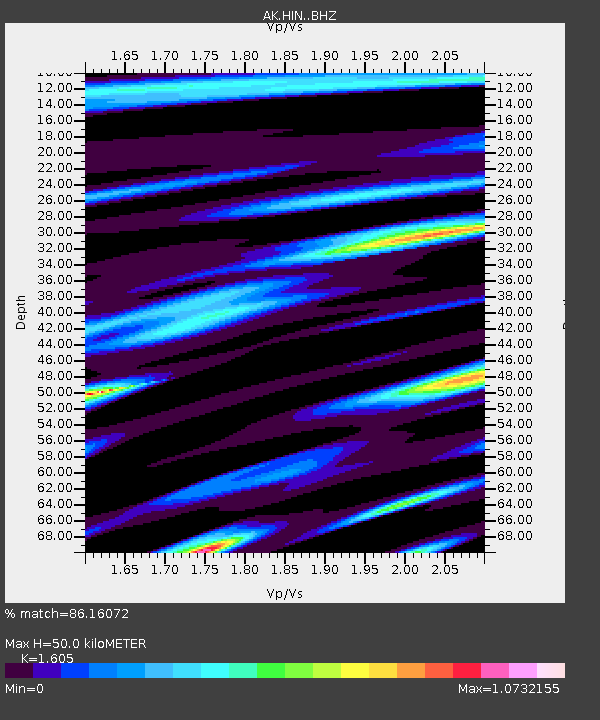
| Estimated Moho Depth: |
50.0 km |
| Estimated Crust Vp/Vs: |
1.61 |
| Assumed Crust Vp: |
6.566 km/s |
| Estimated Crust Vs: |
4.091 km/s |
| Estimated Crust Poisson's Ratio: |
0.18 |
|
| Radial Match: |
86.16072 % |
| Radial Bump: |
400 |
| Transverse Match: |
79.31224 % |
| Transverse Bump: |
400 |
| SOD ConfigId: |
13570011 |
| Insert Time: |
2019-05-02 13:52:39.748 +0000 |
| GWidth: |
2.5 |
| Max Bumps: |
400 |
| Tol: |
0.001 |
|

Signal To Noise
| Channel | StoN | STA | LTA |
| AK:HIN: :BHZ:20190222T10:28:56.06802Z | 3.0441005 | 2.8977063E-6 | 9.519089E-7 |
| AK:HIN: :BHN:20190222T10:28:56.06802Z | 1.5055087 | 1.4547173E-6 | 9.662631E-7 |
| AK:HIN: :BHE:20190222T10:28:56.06802Z | 1.3916147 | 1.4761545E-6 | 1.0607495E-6 |
| Arrivals |
| Ps | 4.8 SECOND |
| PpPs | 19 SECOND |
| PsPs/PpSs | 24 SECOND |


