You are here: Home > Network List > AV - Alaska Volcano Observatory Stations List
> Station AUJA Augustine Junction, Augustine Volcano, Alaska > Earthquake Result Viewer
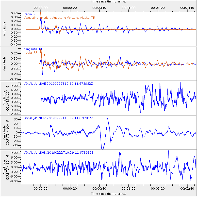
AUJA Augustine Junction, Augustine Volcano, Alaska - Earthquake Result Viewer

| Earthquake location: |
Peru-Ecuador Border Region |
| Earthquake latitude/longitude: |
-2.2/-77.0 |
| Earthquake time(UTC): |
2019/02/22 (053) 10:17:22 GMT |
| Earthquake Depth: |
132 km |
| Earthquake Magnitude: |
7.5 mww |
| Earthquake Catalog/Contributor: |
NEIC PDE/us |
|
| Network: |
AV Alaska Volcano Observatory |
| Station: |
AUJA Augustine Junction, Augustine Volcano, Alaska |
| Lat/Lon: |
59.34 N/153.42 W |
| Elevation: |
376 m |
|
| Distance: |
85.0 deg |
| Az: |
329.997 deg |
| Baz: |
102.836 deg |
| Ray Param: |
0.04480374 |
| Estimated Moho Depth: |
22.75 km |
| Estimated Crust Vp/Vs: |
1.73 |
| Assumed Crust Vp: |
5.989 km/s |
| Estimated Crust Vs: |
3.457 km/s |
| Estimated Crust Poisson's Ratio: |
0.25 |
|
| Radial Match: |
85.857506 % |
| Radial Bump: |
400 |
| Transverse Match: |
84.21806 % |
| Transverse Bump: |
400 |
| SOD ConfigId: |
13570011 |
| Insert Time: |
2019-05-02 13:53:14.233 +0000 |
| GWidth: |
2.5 |
| Max Bumps: |
400 |
| Tol: |
0.001 |
|
Signal To Noise
| Channel | StoN | STA | LTA |
| AV:AUJA: :BHZ:20190222T10:29:11.678982Z | 2.8999913 | 2.379785E-6 | 8.2061797E-7 |
| AV:AUJA: :BHN:20190222T10:29:11.678982Z | 0.94846666 | 1.0677533E-6 | 1.1257679E-6 |
| AV:AUJA: :BHE:20190222T10:29:11.678982Z | 1.4470905 | 2.114748E-6 | 1.4613793E-6 |
| Arrivals |
| Ps | 2.8 SECOND |
| PpPs | 10 SECOND |
| PsPs/PpSs | 13 SECOND |


