You are here: Home > Network List > AV - Alaska Volcano Observatory Stations List
> Station MAPS Pakushin Southeast, Makushin Volcano, Alaska > Earthquake Result Viewer
MAPS Pakushin Southeast, Makushin Volcano, Alaska - Earthquake Result Viewer
| Earthquake location: |
Peru-Ecuador Border Region |
| Earthquake latitude/longitude: |
-2.2/-77.0 |
| Earthquake time(UTC): |
2019/02/22 (053) 10:17:22 GMT |
| Earthquake Depth: |
132 km |
| Earthquake Magnitude: |
7.5 mww |
| Earthquake Catalog/Contributor: |
NEIC PDE/us |
|
| Network: |
AV Alaska Volcano Observatory |
| Station: |
MAPS Pakushin Southeast, Makushin Volcano, Alaska |
| Lat/Lon: |
53.81 N/166.94 W |
| Elevation: |
333 m |
|
| Distance: |
91.7 deg |
| Az: |
323.606 deg |
| Baz: |
91.362 deg |
| Ray Param: |
0.041511003 |
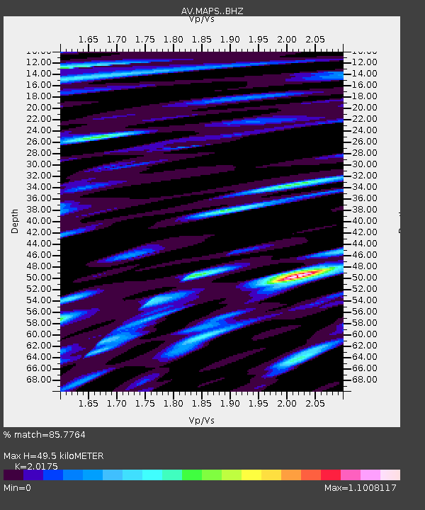
| Estimated Moho Depth: |
49.5 km |
| Estimated Crust Vp/Vs: |
2.02 |
| Assumed Crust Vp: |
3.943 km/s |
| Estimated Crust Vs: |
1.955 km/s |
| Estimated Crust Poisson's Ratio: |
0.34 |
|
| Radial Match: |
85.7764 % |
| Radial Bump: |
400 |
| Transverse Match: |
84.31383 % |
| Transverse Bump: |
400 |
| SOD ConfigId: |
13570011 |
| Insert Time: |
2019-05-02 13:53:20.802 +0000 |
| GWidth: |
2.5 |
| Max Bumps: |
400 |
| Tol: |
0.001 |
|
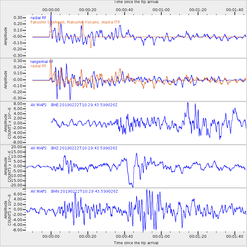
Signal To Noise
| Channel | StoN | STA | LTA |
| AV:MAPS: :BHZ:20190222T10:29:43.599026Z | 3.5315406 | 2.2400736E-6 | 6.3430497E-7 |
| AV:MAPS: :BHN:20190222T10:29:43.599026Z | 1.1224122 | 1.0221977E-6 | 9.107151E-7 |
| AV:MAPS: :BHE:20190222T10:29:43.599026Z | 0.7450011 | 6.471461E-7 | 8.686513E-7 |
| Arrivals |
| Ps | 13 SECOND |
| PpPs | 38 SECOND |
| PsPs/PpSs | 50 SECOND |


