You are here: Home > Network List > AV - Alaska Volcano Observatory Stations List
> Station SPCG Capps Glacier, Mount Spurr, Alaska > Earthquake Result Viewer
SPCG Capps Glacier, Mount Spurr, Alaska - Earthquake Result Viewer
| Earthquake location: |
Peru-Ecuador Border Region |
| Earthquake latitude/longitude: |
-2.2/-77.0 |
| Earthquake time(UTC): |
2019/02/22 (053) 10:17:22 GMT |
| Earthquake Depth: |
132 km |
| Earthquake Magnitude: |
7.5 mww |
| Earthquake Catalog/Contributor: |
NEIC PDE/us |
|
| Network: |
AV Alaska Volcano Observatory |
| Station: |
SPCG Capps Glacier, Mount Spurr, Alaska |
| Lat/Lon: |
61.29 N/152.02 W |
| Elevation: |
1329 m |
|
| Distance: |
84.7 deg |
| Az: |
332.073 deg |
| Baz: |
104.239 deg |
| Ray Param: |
0.044960737 |
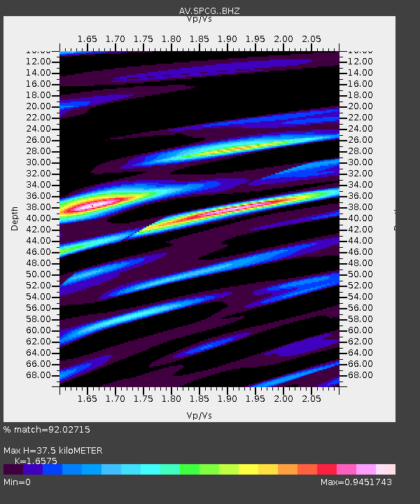
| Estimated Moho Depth: |
37.5 km |
| Estimated Crust Vp/Vs: |
1.66 |
| Assumed Crust Vp: |
6.566 km/s |
| Estimated Crust Vs: |
3.961 km/s |
| Estimated Crust Poisson's Ratio: |
0.21 |
|
| Radial Match: |
92.02715 % |
| Radial Bump: |
400 |
| Transverse Match: |
89.92546 % |
| Transverse Bump: |
400 |
| SOD ConfigId: |
13570011 |
| Insert Time: |
2019-05-02 13:53:33.846 +0000 |
| GWidth: |
2.5 |
| Max Bumps: |
400 |
| Tol: |
0.001 |
|

Signal To Noise
| Channel | StoN | STA | LTA |
| AV:SPCG: :BHZ:20190222T10:29:10.579983Z | 8.201143 | 1.627627E-6 | 1.9846341E-7 |
| AV:SPCG: :BHN:20190222T10:29:10.579983Z | 2.163676 | 5.463593E-7 | 2.5251435E-7 |
| AV:SPCG: :BHE:20190222T10:29:10.579983Z | 1.9113395 | 5.9188426E-7 | 3.0966987E-7 |
| Arrivals |
| Ps | 3.9 SECOND |
| PpPs | 15 SECOND |
| PsPs/PpSs | 19 SECOND |


