You are here: Home > Network List > TA - USArray Transportable Network (new EarthScope stations) Stations List
> Station 627A Terlingua Ranch, Terlingua, TX, USA > Earthquake Result Viewer
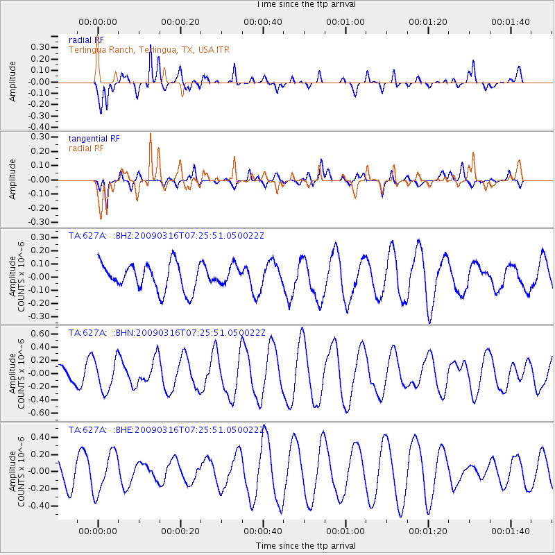
627A Terlingua Ranch, Terlingua, TX, USA - Earthquake Result Viewer
*The percent match for this event was below the threshold and hence no stack was calculated.
| Earthquake location: |
Pacific-Antarctic Ridge |
| Earthquake latitude/longitude: |
-55.1/-129.7 |
| Earthquake time(UTC): |
2009/03/16 (075) 07:13:36 GMT |
| Earthquake Depth: |
10 km |
| Earthquake Magnitude: |
5.9 MW, 5.2 MS, 5.1 MB, 5.9 MW |
| Earthquake Catalog/Contributor: |
WHDF/NEIC |
|
| Network: |
TA USArray Transportable Network (new EarthScope stations) |
| Station: |
627A Terlingua Ranch, Terlingua, TX, USA |
| Lat/Lon: |
29.45 N/103.39 W |
| Elevation: |
1163 m |
|
| Distance: |
87.2 deg |
| Az: |
22.77 deg |
| Baz: |
194.76 deg |
| Ray Param: |
$rayparam |
*The percent match for this event was below the threshold and hence was not used in the summary stack. |
|
| Radial Match: |
81.9313 % |
| Radial Bump: |
288 |
| Transverse Match: |
53.154896 % |
| Transverse Bump: |
400 |
| SOD ConfigId: |
2658 |
| Insert Time: |
2010-03-06 20:16:02.489 +0000 |
| GWidth: |
2.5 |
| Max Bumps: |
400 |
| Tol: |
0.001 |
|
Signal To Noise
| Channel | StoN | STA | LTA |
| TA:627A: :BHN:20090316T07:25:51.050022Z | 1.9284377 | 2.3423635E-7 | 1.2146431E-7 |
| TA:627A: :BHE:20090316T07:25:51.050022Z | 1.8754451 | 2.375234E-7 | 1.2664908E-7 |
| TA:627A: :BHZ:20090316T07:25:51.050022Z | 0.70192814 | 7.243755E-8 | 1.03197955E-7 |
| Arrivals |
| Ps | |
| PpPs | |
| PsPs/PpSs | |


