You are here: Home > Network List > US - United States National Seismic Network Stations List
> Station DGMT Dagmar, Montana, USA > Earthquake Result Viewer
DGMT Dagmar, Montana, USA - Earthquake Result Viewer
| Earthquake location: |
Southeast Of Honshu, Japan |
| Earthquake latitude/longitude: |
30.5/142.1 |
| Earthquake time(UTC): |
2016/09/20 (264) 16:21:16 GMT |
| Earthquake Depth: |
10 km |
| Earthquake Magnitude: |
6.1 MWW, 6.0 MWB |
| Earthquake Catalog/Contributor: |
NEIC PDE/NEIC COMCAT |
|
| Network: |
US United States National Seismic Network |
| Station: |
DGMT Dagmar, Montana, USA |
| Lat/Lon: |
48.47 N/104.20 W |
| Elevation: |
0.0 m |
|
| Distance: |
81.6 deg |
| Az: |
38.016 deg |
| Baz: |
307.017 deg |
| Ray Param: |
0.0474827 |
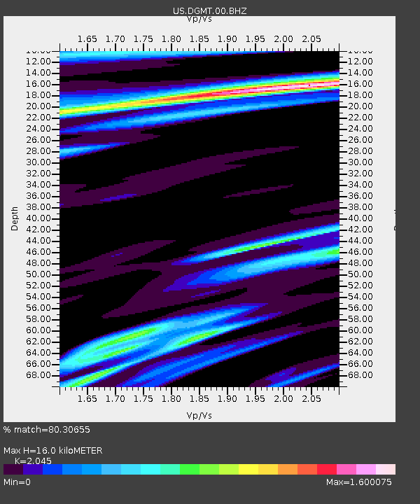
| Estimated Moho Depth: |
16.0 km |
| Estimated Crust Vp/Vs: |
2.05 |
| Assumed Crust Vp: |
6.438 km/s |
| Estimated Crust Vs: |
3.148 km/s |
| Estimated Crust Poisson's Ratio: |
0.34 |
|
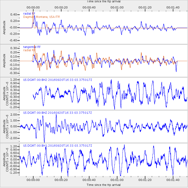
| Radial Match: |
80.30655 % |
| Radial Bump: |
378 |
| Transverse Match: |
59.879223 % |
| Transverse Bump: |
381 |
| SOD ConfigId: |
1634031 |
| Insert Time: |
2016-10-04 16:27:37.438 +0000 |
| GWidth: |
2.5 |
| Max Bumps: |
400 |
| Tol: |
0.001 |
|
Signal To Noise
| Channel | StoN | STA | LTA |
| US:DGMT:00:BHZ:20160920T16:33:03.375017Z | 4.7230077 | 8.0476775E-7 | 1.7039305E-7 |
| US:DGMT:00:BH1:20160920T16:33:03.375017Z | 0.8230741 | 2.7927237E-7 | 3.3930405E-7 |
| US:DGMT:00:BH2:20160920T16:33:03.375017Z | 1.4288716 | 4.757289E-7 | 3.3294026E-7 |
| Arrivals |
| Ps | 2.7 SECOND |
| PpPs | 7.4 SECOND |
| PsPs/PpSs | 10 SECOND |


