You are here: Home > Network List > C1 - Red Sismologica Nacional Stations List
> Station MG05 Puerto Natales > Earthquake Result Viewer
MG05 Puerto Natales - Earthquake Result Viewer
| Earthquake location: |
Peru-Ecuador Border Region |
| Earthquake latitude/longitude: |
-2.2/-77.0 |
| Earthquake time(UTC): |
2019/02/22 (053) 10:17:22 GMT |
| Earthquake Depth: |
132 km |
| Earthquake Magnitude: |
7.5 mww |
| Earthquake Catalog/Contributor: |
NEIC PDE/us |
|
| Network: |
C1 Red Sismologica Nacional |
| Station: |
MG05 Puerto Natales |
| Lat/Lon: |
51.68 S/72.50 W |
| Elevation: |
99 m |
|
| Distance: |
49.5 deg |
| Az: |
176.298 deg |
| Baz: |
354.052 deg |
| Ray Param: |
0.06824548 |
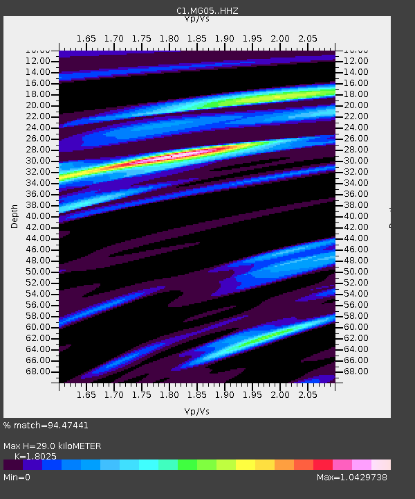
| Estimated Moho Depth: |
29.0 km |
| Estimated Crust Vp/Vs: |
1.80 |
| Assumed Crust Vp: |
6.438 km/s |
| Estimated Crust Vs: |
3.572 km/s |
| Estimated Crust Poisson's Ratio: |
0.28 |
|
| Radial Match: |
94.47441 % |
| Radial Bump: |
400 |
| Transverse Match: |
90.49362 % |
| Transverse Bump: |
400 |
| SOD ConfigId: |
13570011 |
| Insert Time: |
2019-05-02 13:54:29.947 +0000 |
| GWidth: |
2.5 |
| Max Bumps: |
400 |
| Tol: |
0.001 |
|

Signal To Noise
| Channel | StoN | STA | LTA |
| C1:MG05: :HHZ:20190222T10:25:28.529995Z | 44.34491 | 3.350662E-5 | 7.555912E-7 |
| C1:MG05: :HHN:20190222T10:25:28.529995Z | 32.379837 | 1.7731252E-5 | 5.4760164E-7 |
| C1:MG05: :HHE:20190222T10:25:28.529995Z | 4.1717906 | 1.9910535E-6 | 4.772659E-7 |
| Arrivals |
| Ps | 3.8 SECOND |
| PpPs | 12 SECOND |
| PsPs/PpSs | 16 SECOND |


