You are here: Home > Network List > C1 - Red Sismologica Nacional Stations List
> Station ML02 Panimavida > Earthquake Result Viewer
ML02 Panimavida - Earthquake Result Viewer
| Earthquake location: |
Peru-Ecuador Border Region |
| Earthquake latitude/longitude: |
-2.2/-77.0 |
| Earthquake time(UTC): |
2019/02/22 (053) 10:17:22 GMT |
| Earthquake Depth: |
132 km |
| Earthquake Magnitude: |
7.5 mww |
| Earthquake Catalog/Contributor: |
NEIC PDE/us |
|
| Network: |
C1 Red Sismologica Nacional |
| Station: |
ML02 Panimavida |
| Lat/Lon: |
35.76 S/71.42 W |
| Elevation: |
237 m |
|
| Distance: |
33.8 deg |
| Az: |
171.79 deg |
| Baz: |
349.895 deg |
| Ray Param: |
0.07763242 |
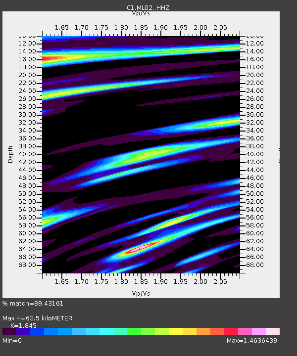
| Estimated Moho Depth: |
63.5 km |
| Estimated Crust Vp/Vs: |
1.85 |
| Assumed Crust Vp: |
6.481 km/s |
| Estimated Crust Vs: |
3.513 km/s |
| Estimated Crust Poisson's Ratio: |
0.29 |
|
| Radial Match: |
89.43161 % |
| Radial Bump: |
400 |
| Transverse Match: |
69.31873 % |
| Transverse Bump: |
400 |
| SOD ConfigId: |
13570011 |
| Insert Time: |
2019-05-02 13:54:31.153 +0000 |
| GWidth: |
2.5 |
| Max Bumps: |
400 |
| Tol: |
0.001 |
|

Signal To Noise
| Channel | StoN | STA | LTA |
| C1:ML02: :HHZ:20190222T10:23:21.469998Z | 81.22113 | 4.5085093E-5 | 5.5509065E-7 |
| C1:ML02: :HHN:20190222T10:23:21.469998Z | 50.674046 | 2.5743182E-5 | 5.0801515E-7 |
| C1:ML02: :HHE:20190222T10:23:21.469998Z | 24.114 | 7.69689E-6 | 3.191876E-7 |
| Arrivals |
| Ps | 8.9 SECOND |
| PpPs | 26 SECOND |
| PsPs/PpSs | 35 SECOND |


