You are here: Home > Network List > TA - USArray Transportable Network (new EarthScope stations) Stations List
> Station 627A Terlingua Ranch, Terlingua, TX, USA > Earthquake Result Viewer
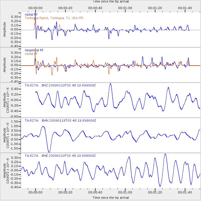
627A Terlingua Ranch, Terlingua, TX, USA - Earthquake Result Viewer
*The percent match for this event was below the threshold and hence no stack was calculated.
| Earthquake location: |
Southeast Of Loyalty Islands |
| Earthquake latitude/longitude: |
-22.6/170.9 |
| Earthquake time(UTC): |
2009/01/19 (019) 03:35:18 GMT |
| Earthquake Depth: |
12 km |
| Earthquake Magnitude: |
5.7 MB, 6.4 MS, 6.5 MW, 6.5 MW |
| Earthquake Catalog/Contributor: |
WHDF/NEIC |
|
| Network: |
TA USArray Transportable Network (new EarthScope stations) |
| Station: |
627A Terlingua Ranch, Terlingua, TX, USA |
| Lat/Lon: |
29.45 N/103.39 W |
| Elevation: |
1163 m |
|
| Distance: |
97.3 deg |
| Az: |
61.253 deg |
| Baz: |
248.28 deg |
| Ray Param: |
$rayparam |
*The percent match for this event was below the threshold and hence was not used in the summary stack. |
|
| Radial Match: |
74.22331 % |
| Radial Bump: |
400 |
| Transverse Match: |
68.58084 % |
| Transverse Bump: |
400 |
| SOD ConfigId: |
2658 |
| Insert Time: |
2010-03-06 20:16:08.635 +0000 |
| GWidth: |
2.5 |
| Max Bumps: |
400 |
| Tol: |
0.001 |
|
Signal To Noise
| Channel | StoN | STA | LTA |
| TA:627A: :BHN:20090119T03:48:19.699009Z | 1.9865083 | 4.3795697E-7 | 2.2046572E-7 |
| TA:627A: :BHE:20090119T03:48:19.699009Z | 0.7475318 | 1.018726E-7 | 1.3627862E-7 |
| TA:627A: :BHZ:20090119T03:48:19.699009Z | 1.3426408 | 2.20688E-7 | 1.643686E-7 |
| Arrivals |
| Ps | |
| PpPs | |
| PsPs/PpSs | |


