You are here: Home > Network List > CC - Cascade Chain Volcano Monitoring Stations List
> Station SWF2 Southwest Flank moved down hill, Mt. St. Helens, WA > Earthquake Result Viewer
SWF2 Southwest Flank moved down hill, Mt. St. Helens, WA - Earthquake Result Viewer
| Earthquake location: |
Peru-Ecuador Border Region |
| Earthquake latitude/longitude: |
-2.2/-77.0 |
| Earthquake time(UTC): |
2019/02/22 (053) 10:17:22 GMT |
| Earthquake Depth: |
132 km |
| Earthquake Magnitude: |
7.5 mww |
| Earthquake Catalog/Contributor: |
NEIC PDE/us |
|
| Network: |
CC Cascade Chain Volcano Monitoring |
| Station: |
SWF2 Southwest Flank moved down hill, Mt. St. Helens, WA |
| Lat/Lon: |
46.18 N/122.22 W |
| Elevation: |
1548 m |
|
| Distance: |
62.5 deg |
| Az: |
326.233 deg |
| Baz: |
126.931 deg |
| Ray Param: |
0.059810486 |
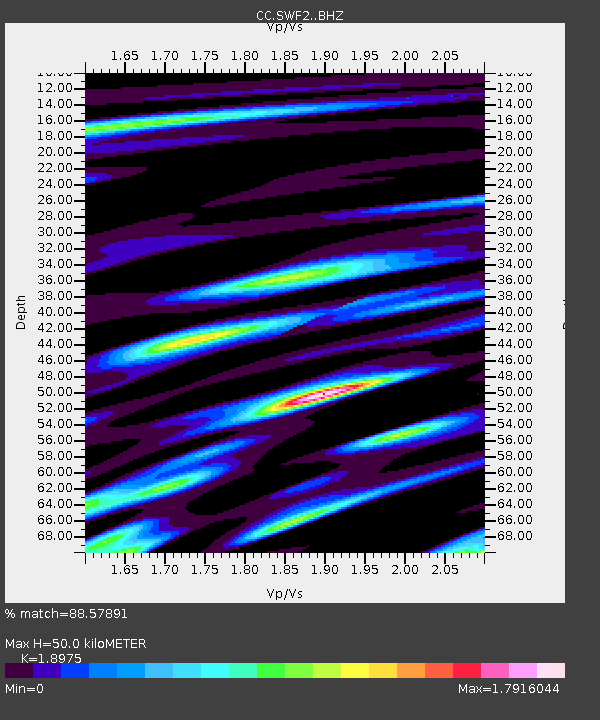
| Estimated Moho Depth: |
50.0 km |
| Estimated Crust Vp/Vs: |
1.90 |
| Assumed Crust Vp: |
6.566 km/s |
| Estimated Crust Vs: |
3.46 km/s |
| Estimated Crust Poisson's Ratio: |
0.31 |
|
| Radial Match: |
88.57891 % |
| Radial Bump: |
400 |
| Transverse Match: |
79.89313 % |
| Transverse Bump: |
400 |
| SOD ConfigId: |
13570011 |
| Insert Time: |
2019-05-02 13:55:14.108 +0000 |
| GWidth: |
2.5 |
| Max Bumps: |
400 |
| Tol: |
0.001 |
|

Signal To Noise
| Channel | StoN | STA | LTA |
| CC:SWF2: :BHZ:20190222T10:27:01.079983Z | 7.30256 | 3.1288826E-6 | 4.284638E-7 |
| CC:SWF2: :BHN:20190222T10:27:01.079983Z | 2.4041705 | 1.1566922E-6 | 4.8111906E-7 |
| CC:SWF2: :BHE:20190222T10:27:01.079983Z | 2.1720705 | 1.8135E-6 | 8.3491767E-7 |
| Arrivals |
| Ps | 7.1 SECOND |
| PpPs | 21 SECOND |
| PsPs/PpSs | 28 SECOND |


