You are here: Home > Network List > CI - Caltech Regional Seismic Network Stations List
> Station MUR Murrieta > Earthquake Result Viewer
MUR Murrieta - Earthquake Result Viewer

| Earthquake location: |
Peru-Ecuador Border Region |
| Earthquake latitude/longitude: |
-2.2/-77.0 |
| Earthquake time(UTC): |
2019/02/22 (053) 10:17:22 GMT |
| Earthquake Depth: |
132 km |
| Earthquake Magnitude: |
7.5 mww |
| Earthquake Catalog/Contributor: |
NEIC PDE/us |
|
| Network: |
CI Caltech Regional Seismic Network |
| Station: |
MUR Murrieta |
| Lat/Lon: |
33.60 N/117.20 W |
| Elevation: |
562 m |
|
| Distance: |
52.0 deg |
| Az: |
316.868 deg |
| Baz: |
125.061 deg |
| Ray Param: |
0.066635296 |
| Estimated Moho Depth: |
32.25 km |
| Estimated Crust Vp/Vs: |
1.81 |
| Assumed Crust Vp: |
6.264 km/s |
| Estimated Crust Vs: |
3.47 km/s |
| Estimated Crust Poisson's Ratio: |
0.28 |
|
| Radial Match: |
98.070946 % |
| Radial Bump: |
400 |
| Transverse Match: |
88.55882 % |
| Transverse Bump: |
400 |
| SOD ConfigId: |
13570011 |
| Insert Time: |
2019-05-02 13:55:53.313 +0000 |
| GWidth: |
2.5 |
| Max Bumps: |
400 |
| Tol: |
0.001 |
|
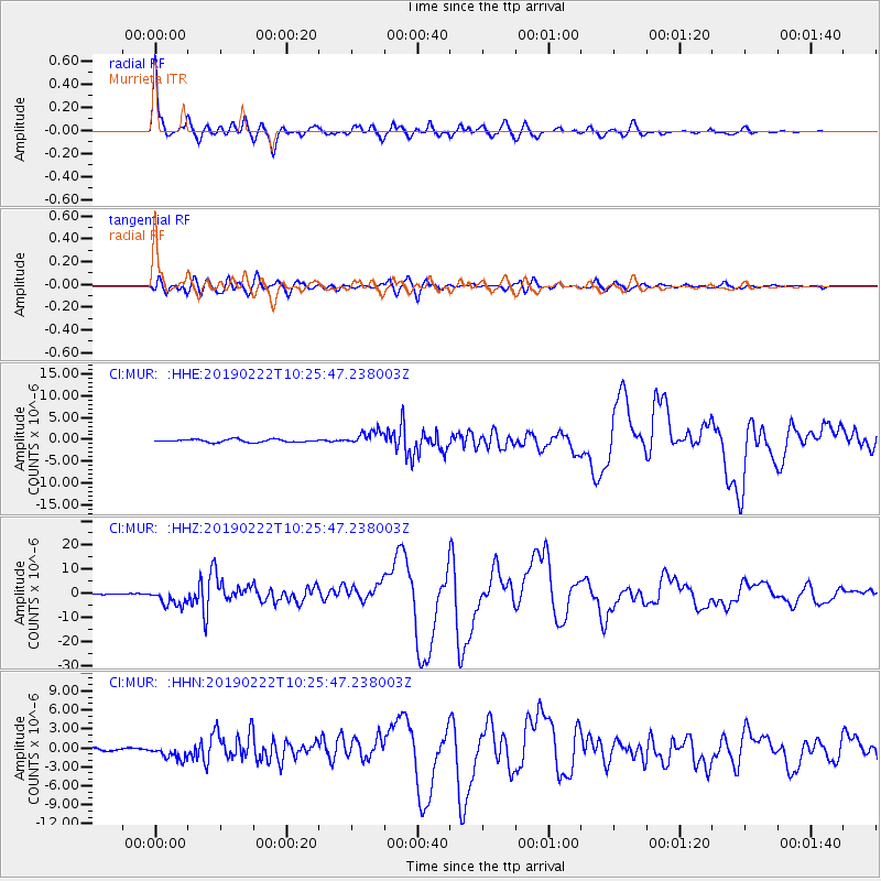
Signal To Noise
| Channel | StoN | STA | LTA |
| CI:MUR: :HHZ:20190222T10:25:47.238003Z | 13.718486 | 3.5927621E-6 | 2.61892E-7 |
| CI:MUR: :HHN:20190222T10:25:47.238003Z | 6.756194 | 1.140993E-6 | 1.6888103E-7 |
| CI:MUR: :HHE:20190222T10:25:47.238003Z | 4.969412 | 1.6133537E-6 | 3.2465687E-7 |
| Arrivals |
| Ps | 4.4 SECOND |
| PpPs | 14 SECOND |
| PsPs/PpSs | 18 SECOND |


