You are here: Home > Network List > US - United States National Seismic Network Stations List
> Station MSO Missoula, Montana, USA > Earthquake Result Viewer
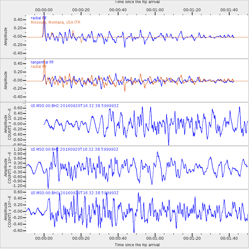
MSO Missoula, Montana, USA - Earthquake Result Viewer
*The percent match for this event was below the threshold and hence no stack was calculated.
| Earthquake location: |
Southeast Of Honshu, Japan |
| Earthquake latitude/longitude: |
30.5/142.1 |
| Earthquake time(UTC): |
2016/09/20 (264) 16:21:16 GMT |
| Earthquake Depth: |
10 km |
| Earthquake Magnitude: |
6.1 MWW, 6.0 MWB |
| Earthquake Catalog/Contributor: |
NEIC PDE/NEIC COMCAT |
|
| Network: |
US United States National Seismic Network |
| Station: |
MSO Missoula, Montana, USA |
| Lat/Lon: |
46.83 N/113.94 W |
| Elevation: |
1264 m |
|
| Distance: |
77.0 deg |
| Az: |
43.135 deg |
| Baz: |
300.779 deg |
| Ray Param: |
$rayparam |
*The percent match for this event was below the threshold and hence was not used in the summary stack. |
|
| Radial Match: |
71.973724 % |
| Radial Bump: |
400 |
| Transverse Match: |
61.140736 % |
| Transverse Bump: |
400 |
| SOD ConfigId: |
1634031 |
| Insert Time: |
2016-10-04 16:28:27.478 +0000 |
| GWidth: |
2.5 |
| Max Bumps: |
400 |
| Tol: |
0.001 |
|
Signal To Noise
| Channel | StoN | STA | LTA |
| US:MSO:00:BHZ:20160920T16:32:38.599993Z | 3.8490133 | 4.7137547E-7 | 1.2246657E-7 |
| US:MSO:00:BH1:20160920T16:32:38.599993Z | 1.9657868 | 1.9665654E-7 | 1.00039614E-7 |
| US:MSO:00:BH2:20160920T16:32:38.599993Z | 2.2164102 | 2.633726E-7 | 1.18828474E-7 |
| Arrivals |
| Ps | |
| PpPs | |
| PsPs/PpSs | |


