You are here: Home > Network List > CN - Canadian National Seismograph Network Stations List
> Station SYMB Survey Mountain, BC, CA > Earthquake Result Viewer
SYMB Survey Mountain, BC, CA - Earthquake Result Viewer
| Earthquake location: |
Peru-Ecuador Border Region |
| Earthquake latitude/longitude: |
-2.2/-77.0 |
| Earthquake time(UTC): |
2019/02/22 (053) 10:17:22 GMT |
| Earthquake Depth: |
132 km |
| Earthquake Magnitude: |
7.5 mww |
| Earthquake Catalog/Contributor: |
NEIC PDE/us |
|
| Network: |
CN Canadian National Seismograph Network |
| Station: |
SYMB Survey Mountain, BC, CA |
| Lat/Lon: |
48.56 N/123.80 W |
| Elevation: |
945 m |
|
| Distance: |
64.8 deg |
| Az: |
327.648 deg |
| Baz: |
126.4 deg |
| Ray Param: |
0.058333505 |
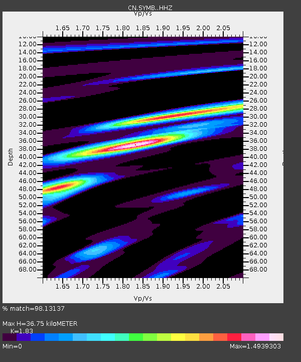
| Estimated Moho Depth: |
36.75 km |
| Estimated Crust Vp/Vs: |
1.83 |
| Assumed Crust Vp: |
6.566 km/s |
| Estimated Crust Vs: |
3.588 km/s |
| Estimated Crust Poisson's Ratio: |
0.29 |
|
| Radial Match: |
98.13137 % |
| Radial Bump: |
345 |
| Transverse Match: |
89.72683 % |
| Transverse Bump: |
400 |
| SOD ConfigId: |
13570011 |
| Insert Time: |
2019-05-02 13:57:27.806 +0000 |
| GWidth: |
2.5 |
| Max Bumps: |
400 |
| Tol: |
0.001 |
|

Signal To Noise
| Channel | StoN | STA | LTA |
| CN:SYMB: :HHZ:20190222T10:27:16.029995Z | 12.442861 | 2.8982763E-6 | 2.3292685E-7 |
| CN:SYMB: :HHN:20190222T10:27:16.029995Z | 2.431557 | 7.224E-7 | 2.970936E-7 |
| CN:SYMB: :HHE:20190222T10:27:16.029995Z | 4.5492754 | 1.428353E-6 | 3.1397374E-7 |
| Arrivals |
| Ps | 4.8 SECOND |
| PpPs | 15 SECOND |
| PsPs/PpSs | 20 SECOND |


