You are here: Home > Network List > TA - USArray Transportable Network (new EarthScope stations) Stations List
> Station R25A Fountain Ranch, Boone, CO, USA > Earthquake Result Viewer
R25A Fountain Ranch, Boone, CO, USA - Earthquake Result Viewer
| Earthquake location: |
Kuril Islands |
| Earthquake latitude/longitude: |
51.0/157.6 |
| Earthquake time(UTC): |
2008/07/24 (206) 01:43:16 GMT |
| Earthquake Depth: |
27 km |
| Earthquake Magnitude: |
6.0 MB, 6.0 MS, 6.2 MW, 6.2 MW |
| Earthquake Catalog/Contributor: |
WHDF/NEIC |
|
| Network: |
TA USArray Transportable Network (new EarthScope stations) |
| Station: |
R25A Fountain Ranch, Boone, CO, USA |
| Lat/Lon: |
38.15 N/104.28 W |
| Elevation: |
1461 m |
|
| Distance: |
66.0 deg |
| Az: |
58.657 deg |
| Baz: |
316.768 deg |
| Ray Param: |
0.057835314 |
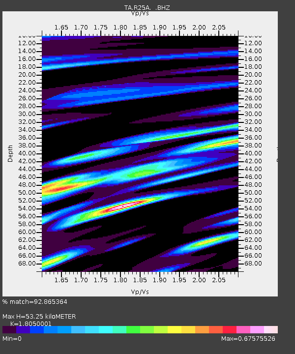
| Estimated Moho Depth: |
53.25 km |
| Estimated Crust Vp/Vs: |
1.81 |
| Assumed Crust Vp: |
6.159 km/s |
| Estimated Crust Vs: |
3.412 km/s |
| Estimated Crust Poisson's Ratio: |
0.28 |
|
| Radial Match: |
92.865364 % |
| Radial Bump: |
363 |
| Transverse Match: |
79.73491 % |
| Transverse Bump: |
400 |
| SOD ConfigId: |
2504 |
| Insert Time: |
2010-03-06 20:17:01.524 +0000 |
| GWidth: |
2.5 |
| Max Bumps: |
400 |
| Tol: |
0.001 |
|
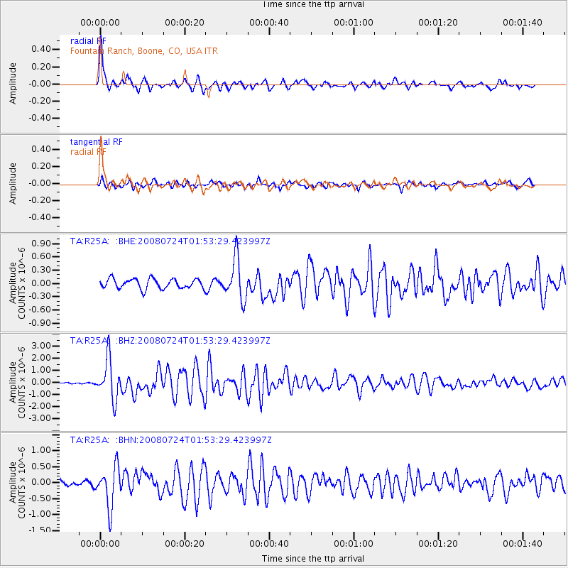
Signal To Noise
| Channel | StoN | STA | LTA |
| TA:R25A: :BHZ:20080724T01:53:29.423997Z | 19.342207 | 1.6965502E-6 | 8.771233E-8 |
| TA:R25A: :BHN:20080724T01:53:29.423997Z | 6.8531175 | 6.491444E-7 | 9.4722495E-8 |
| TA:R25A: :BHE:20080724T01:53:29.423997Z | 4.2734175 | 4.7041559E-7 | 1.1007949E-7 |
| Arrivals |
| Ps | 7.2 SECOND |
| PpPs | 23 SECOND |
| PsPs/PpSs | 31 SECOND |


