You are here: Home > Network List > TA - USArray Transportable Network (new EarthScope stations) Stations List
> Station R25A Fountain Ranch, Boone, CO, USA > Earthquake Result Viewer
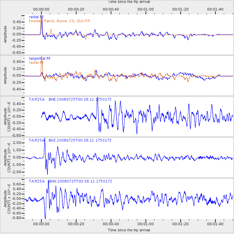
R25A Fountain Ranch, Boone, CO, USA - Earthquake Result Viewer

| Earthquake location: |
Rat Islands, Aleutian Islands |
| Earthquake latitude/longitude: |
51.3/179.0 |
| Earthquake time(UTC): |
2008/07/25 (207) 00:29:22 GMT |
| Earthquake Depth: |
21 km |
| Earthquake Magnitude: |
5.7 MB, 5.5 MS, 5.9 MW, 5.9 MW |
| Earthquake Catalog/Contributor: |
WHDF/NEIC |
|
| Network: |
TA USArray Transportable Network (new EarthScope stations) |
| Station: |
R25A Fountain Ranch, Boone, CO, USA |
| Lat/Lon: |
38.15 N/104.28 W |
| Elevation: |
1461 m |
|
| Distance: |
53.7 deg |
| Az: |
72.255 deg |
| Baz: |
310.648 deg |
| Ray Param: |
0.065909214 |
| Estimated Moho Depth: |
60.5 km |
| Estimated Crust Vp/Vs: |
2.05 |
| Assumed Crust Vp: |
6.159 km/s |
| Estimated Crust Vs: |
3.004 km/s |
| Estimated Crust Poisson's Ratio: |
0.34 |
|
| Radial Match: |
88.592766 % |
| Radial Bump: |
400 |
| Transverse Match: |
67.52029 % |
| Transverse Bump: |
400 |
| SOD ConfigId: |
2504 |
| Insert Time: |
2010-03-06 20:17:02.902 +0000 |
| GWidth: |
2.5 |
| Max Bumps: |
400 |
| Tol: |
0.001 |
|
Signal To Noise
| Channel | StoN | STA | LTA |
| TA:R25A: :BHZ:20080725T00:38:12.175017Z | 13.530207 | 1.0095517E-6 | 7.4614654E-8 |
| TA:R25A: :BHN:20080725T00:38:12.175017Z | 6.222953 | 3.6450243E-7 | 5.8573868E-8 |
| TA:R25A: :BHE:20080725T00:38:12.175017Z | 3.763828 | 2.662682E-7 | 7.074398E-8 |
| Arrivals |
| Ps | 11 SECOND |
| PpPs | 29 SECOND |
| PsPs/PpSs | 39 SECOND |


