You are here: Home > Network List > HV - Hawaiian Volcano Observatory Network Stations List
> Station MLOD Mauna Loa, Hawaii Digital > Earthquake Result Viewer
MLOD Mauna Loa, Hawaii Digital - Earthquake Result Viewer
| Earthquake location: |
Peru-Ecuador Border Region |
| Earthquake latitude/longitude: |
-2.2/-77.0 |
| Earthquake time(UTC): |
2019/02/22 (053) 10:17:22 GMT |
| Earthquake Depth: |
132 km |
| Earthquake Magnitude: |
7.5 mww |
| Earthquake Catalog/Contributor: |
NEIC PDE/us |
|
| Network: |
HV Hawaiian Volcano Observatory Network |
| Station: |
MLOD Mauna Loa, Hawaii Digital |
| Lat/Lon: |
19.49 N/155.39 W |
| Elevation: |
2044 m |
|
| Distance: |
79.8 deg |
| Az: |
290.132 deg |
| Baz: |
95.997 deg |
| Ray Param: |
0.048419893 |
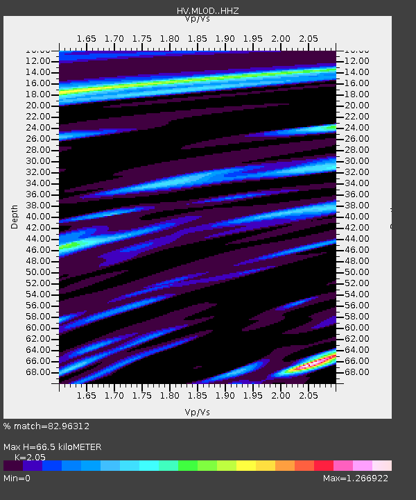
| Estimated Moho Depth: |
66.5 km |
| Estimated Crust Vp/Vs: |
2.05 |
| Assumed Crust Vp: |
5.195 km/s |
| Estimated Crust Vs: |
2.534 km/s |
| Estimated Crust Poisson's Ratio: |
0.34 |
|
| Radial Match: |
82.96312 % |
| Radial Bump: |
400 |
| Transverse Match: |
72.47624 % |
| Transverse Bump: |
400 |
| SOD ConfigId: |
13570011 |
| Insert Time: |
2019-05-02 13:58:58.419 +0000 |
| GWidth: |
2.5 |
| Max Bumps: |
400 |
| Tol: |
0.001 |
|

Signal To Noise
| Channel | StoN | STA | LTA |
| HV:MLOD: :HHZ:20190222T10:28:44.810024Z | 3.024893 | 1.0109446E-5 | 3.3420836E-6 |
| HV:MLOD: :HHN:20190222T10:28:44.810024Z | 1.7403978 | 6.1625183E-6 | 3.5408677E-6 |
| HV:MLOD: :HHE:20190222T10:28:44.810024Z | 2.7336915 | 5.973964E-6 | 2.1853102E-6 |
| Arrivals |
| Ps | 14 SECOND |
| PpPs | 38 SECOND |
| PsPs/PpSs | 52 SECOND |


