You are here: Home > Network List > IU - Global Seismograph Network (GSN - IRIS/USGS) Stations List
> Station MACI Morro de la Arena, Canary Islands > Earthquake Result Viewer
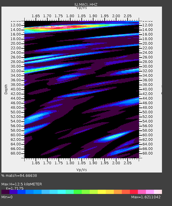
MACI Morro de la Arena, Canary Islands - Earthquake Result Viewer
| Earthquake location: |
Peru-Ecuador Border Region |
| Earthquake latitude/longitude: |
-2.2/-77.0 |
| Earthquake time(UTC): |
2019/02/22 (053) 10:17:22 GMT |
| Earthquake Depth: |
132 km |
| Earthquake Magnitude: |
7.5 mww |
| Earthquake Catalog/Contributor: |
NEIC PDE/us |
|
| Network: |
IU Global Seismograph Network (GSN - IRIS/USGS) |
| Station: |
MACI Morro de la Arena, Canary Islands |
| Lat/Lon: |
28.25 N/16.51 W |
| Elevation: |
1674 m |
|
| Distance: |
65.4 deg |
| Az: |
57.615 deg |
| Baz: |
253.044 deg |
| Ray Param: |
0.057913866 |
| Estimated Moho Depth: |
12.5 km |
| Estimated Crust Vp/Vs: |
1.72 |
| Assumed Crust Vp: |
4.662 km/s |
| Estimated Crust Vs: |
2.715 km/s |
| Estimated Crust Poisson's Ratio: |
0.24 |
|
| Radial Match: |
94.66638 % |
| Radial Bump: |
362 |
| Transverse Match: |
93.59056 % |
| Transverse Bump: |
400 |
| SOD ConfigId: |
13570011 |
| Insert Time: |
2019-05-02 13:59:15.576 +0000 |
| GWidth: |
2.5 |
| Max Bumps: |
400 |
| Tol: |
0.001 |
|

Signal To Noise
| Channel | StoN | STA | LTA |
| IU:MACI: :HHZ:20190222T10:27:20.17001Z | 112.627716 | 4.244239E-5 | 3.7683787E-7 |
| IU:MACI: :HHN:20190222T10:27:20.17001Z | 15.3914385 | 1.2821147E-5 | 8.330051E-7 |
| IU:MACI: :HHE:20190222T10:27:20.17001Z | 41.244946 | 2.8777145E-5 | 6.9771323E-7 |
| Arrivals |
| Ps | 2.0 SECOND |
| PpPs | 7.1 SECOND |
| PsPs/PpSs | 9.1 SECOND |


